


VMS-style Cu-Zn project of roughly 206.4 km² in Central Norway.
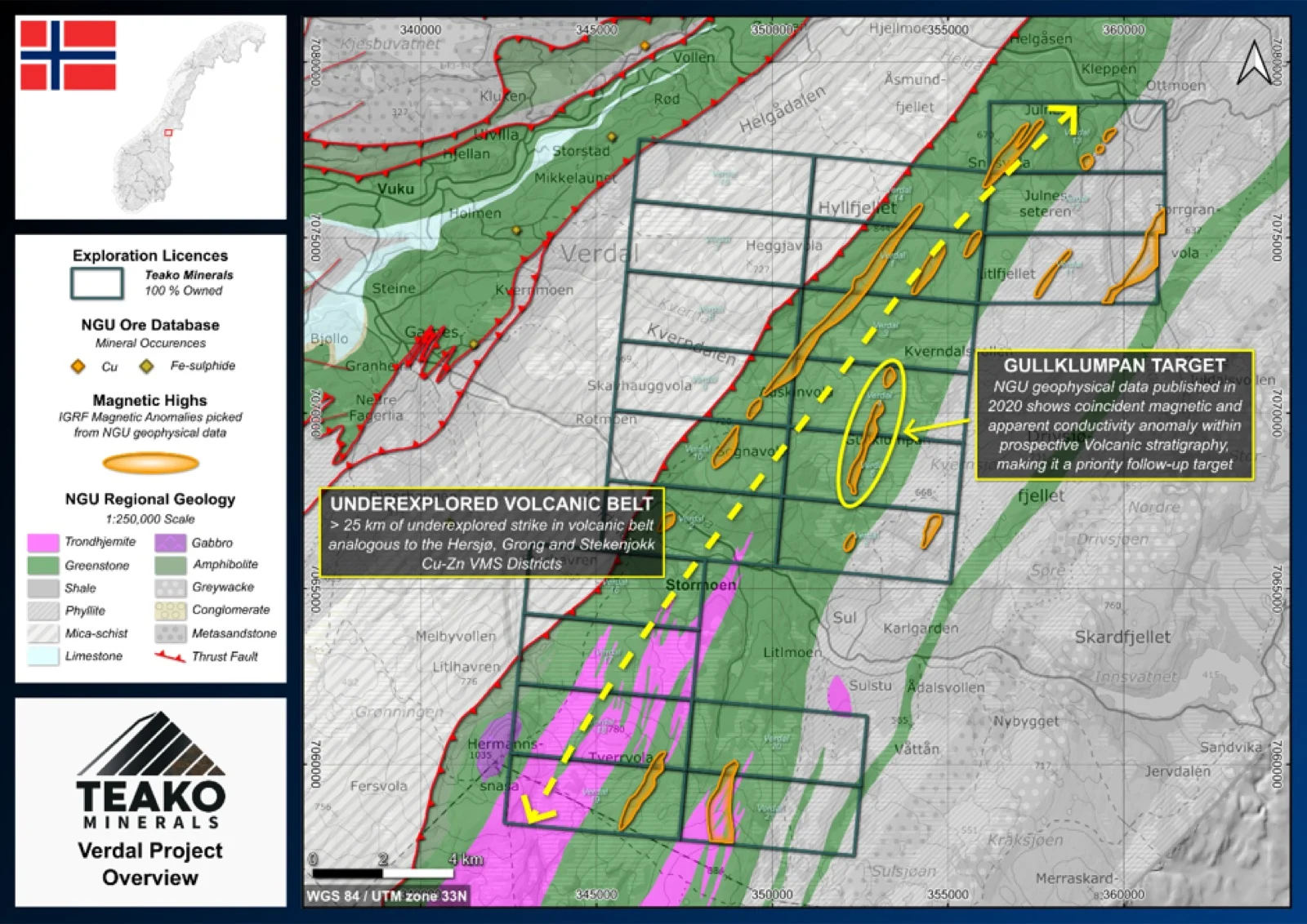
The 100% owned Verdal Project is a district-scale opportunity in an unexplored and highly prospective section of the Folldal-Meråker metallogenic belt. The project covers 206 km2 in the Verdal municipality, from the Inndalen valley in the south to Hyfjellet in the North.
Geologically the Verdal project is focussed on an unexplored segment of the Fundsjø Group, a key prospective volcanic sequence in the Caledonides (Eilu, 2012). The Fundsjø Group and its equivalent units further south (e.g. the Hersjø and Folldal Volcanics) have been directly compared to the volcanic sequence that hosts the Stekenjokk-Levi deposits (Grenne et al., 1995).
No mineral occurrences have been identified on the project to date, yet the promising geology with known deposits, combined with modern geophysics data from the NGU (Ofstad et al., 2022) highlight areas of prospectivity within the Verdal project. The Verdal Project therefore is a highly prospective foothold in one of the least explored regions of the Norwegian Caledonides. The recently available data offers new insights and significantly derisks early-stage exploration in the region. The project covers a prospective bimodal volcanic belt analogous to the host sequence of the Stekenjokk-Levi deposits in Sweden, which Teako believes has the potential to host new Cu-Zn VMS discoveries.
{{fig:1}}
1Teako has not performed sufficient work to verify the published data reported above, but the Company believes this information to be considered reliable and relevant. Results reported are maximum values and may not be representative of all samples collected within the area being evaluated
2References made to nearby mines and analogous deposits provide context for the regional targets but are not necessarily indicative that these targets host similar tonnages or grades of mineralization.
References
Eilu, P. (ed.) (2012) Mineral deposits and metallogeny of Fennoscandia. Espoo: Geological Survey of Finland (Special paper / Geological Survey of Finland, 53).
Grenne, T. et al. (1995) ‘The sequential development of magmatic and ore-forming process es in the Fundsjo Group, Meraker district, Central Norway’, NGU Bulletin, 427, pp. 108–111.
Ofstad, F. et al. (2022) Helicopter-borne magnetic, electromagnetic and radiometric geophysical survey in Verdal and Snåsa area, Trøndelag County. NGU Report 2021.013. NGU, p. 34.
References to the ‘NGU’ regard the ‘Norwegian Geological Survey’, in particular, their Resource Database and are consolidated under this citation for simplicity. For all data sourced from this resource, please refer to: https://geo.ngu.no/kart/mineralressurser_mobil/?lang=eng
Exploration-stage project. Any historical production, grades or estimates quoted in project descriptions are historical in nature, have not been verified by the Company as current mineral resources or reserves, and should not be relied upon. See the cautionary statements and the Qualified Person statement.