


VMS-style Cu-Zn project of roughly 233.8 km² in Central Norway.
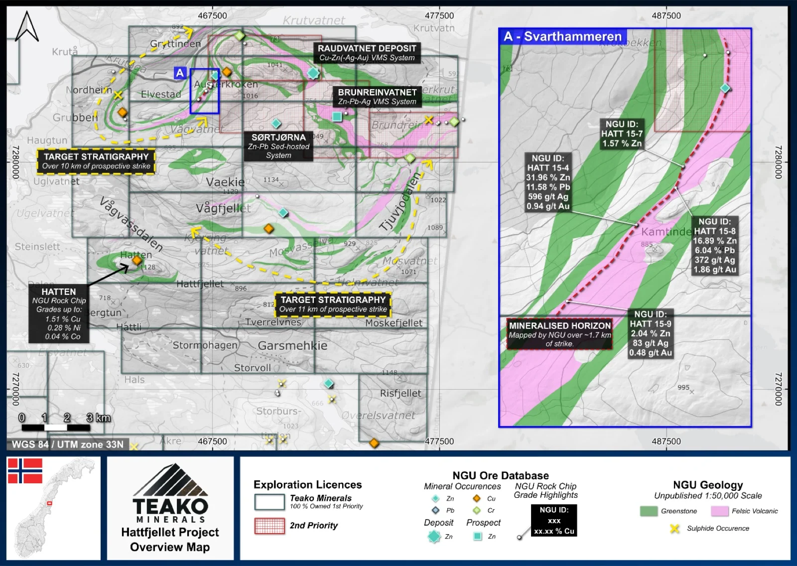
Teako’s 100% owned Hattfjellet project covers an area of 234 km2 and is located in the Hattfjelldal municipality, Nordland. Principal host rocks are keratophyres along the Raudvatnet trend, part of which is currently held under second-priority status. The central question for the VMS exploration concept is whether the Hattfjellet volcanics are of comparable age, geochemical character, and tectonic setting to established Caledonian VMS host sequences such as Stekenjokk and Bathurst (#12)1,2. Geochronological dating of keratophyres within the first-priority areas will be undertaken initially.
The availability of historical drill core from several occurrences provides a cost-effective starting point for this work. Lithogeochemical sampling of archived drill core, particularly from intervals adjacent to ore horizons, would establish a first-pass fertility assessment and allow comparison to regional analogues. Subsequent field mapping traverses should verify and refine NGU mapping around known keratophyre bodies and assess whether additional felsic volcanic centres were overlooked in earlier large-scale surveys. Follow-up field sampling across varying alteration intensities will further constrain the metallogenic framework.
{{fig:1}}
1Teako has not performed sufficient work to verify the published data reported above, but the Company believes this information to be considered reliable and relevant. Results reported are maximum values and may not be representative of all samples collected within the area being evaluated
2References made to nearby mines and analogous deposits provide context for the regional targets but are not necessarily indicative that these targets host similar tonnages or grades of mineralization.
References
Acosta-Gongora et al. (2024). Ore Geology Reviews. A multi-domain approach for soil geochemical anomaly mapping: a case study from the Hattfjelldal area, Norway. Manuscript Draft.
References to the ‘NGU’ regard the ‘Norwegian Geological Survey’, in particular, their Resource Database and are consolidated under this citation for simplicity. For all data sourced from this resource, please refer to: https://geo.ngu.no/kart/mineralressurser_mobil/?lang=eng
Exploration-stage project. Any historical production, grades or estimates quoted in project descriptions are historical in nature, have not been verified by the Company as current mineral resources or reserves, and should not be relied upon. See the cautionary statements and the Qualified Person statement.