


Hydrothermal-style Cu-Zn-Ag-Au project of roughly 38.5 km² in Central Norway.
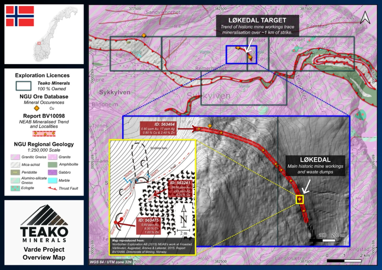
Teako’s 100% owned Varde Project is located in the Sykkylven municipality, Møre og Romsdal, and spans 39 km2 covering the historic Løkedal and Lyshol Cu-Zn-(Ag-Au) occurrences2. Base metal sulphide mineralization is hosted within granitic gneiss with widespread malachite and azurite staining indicating significant secondary Cu enrichment, suggesting oxidation of a primary sulphide occurrence. The Løkedal occurrence has been sampled by the NGU (1977) returning up to 4.8 % Cu and 3.0 % Zn1. Follow-up sampling by NEAB (2015) yielded up to 9.3 % Cu and 2.4 % Zn1. Also, NEAB identified precious metal values of up to 26.5 g/t Au and 223 g/t Ag, together with 6.2% Cu1. The mineralized zone at Løkedal has been traced for over 1 km along strike, with thickness varying from 1.0 to 6.5 m. A brief reconnaissance visit by Teako Minerals in April 2024 confirmed abundant secondary Cu mineralization. For now, the project remains at an early-stage greenfield level. Key next steps include systematic prospecting as well as geochemical and geophysical surveys between Løkedal and Lyshol to test potential connectivity, which could open significant space for subsequent exploration.
{{fig:1}}
1Teako has not performed sufficient work to verify the published data reported above, but the Company believes this information to be considered reliable and relevant. Results reported are maximum values and may not be representative of all samples collected within the area being evaluated
2References made to nearby mines and analogous deposits provide context for the regional targets but are not necessarily indicative that these targets host similar tonnages or grades of mineralization.
References
Norrbotten Exploration AB (2015) NEAB’s work at Froastad, Vårlinuten, Augastad, Årsnes & Løkedal, 2015. Report BV10098. Directorate of Mining, Norway. Available at: https://www.dirmin.no/files/bibliotek/BV10098.pdf (Accessed: 1 March 2026).
BV42: Korneliussen et al. (1977). Malmundersøkelser i Møre og Romsdal – NGU Vestlandsprogrammet.
References to the ‘NGU’ regard the ‘Norwegian Geological Survey’, in particular, their Resource Database and are consolidated under this citation for simplicity. For all data sourced from this resource, please refer to: https://geo.ngu.no/kart/mineralressurser_mobil/?lang=eng
Exploration-stage project. Any historical production, grades or estimates quoted in project descriptions are historical in nature, have not been verified by the Company as current mineral resources or reserves, and should not be relied upon. See the cautionary statements and the Qualified Person statement.