


VMS-style Cu-Zn project of roughly 85.1 km² in Central Norway.
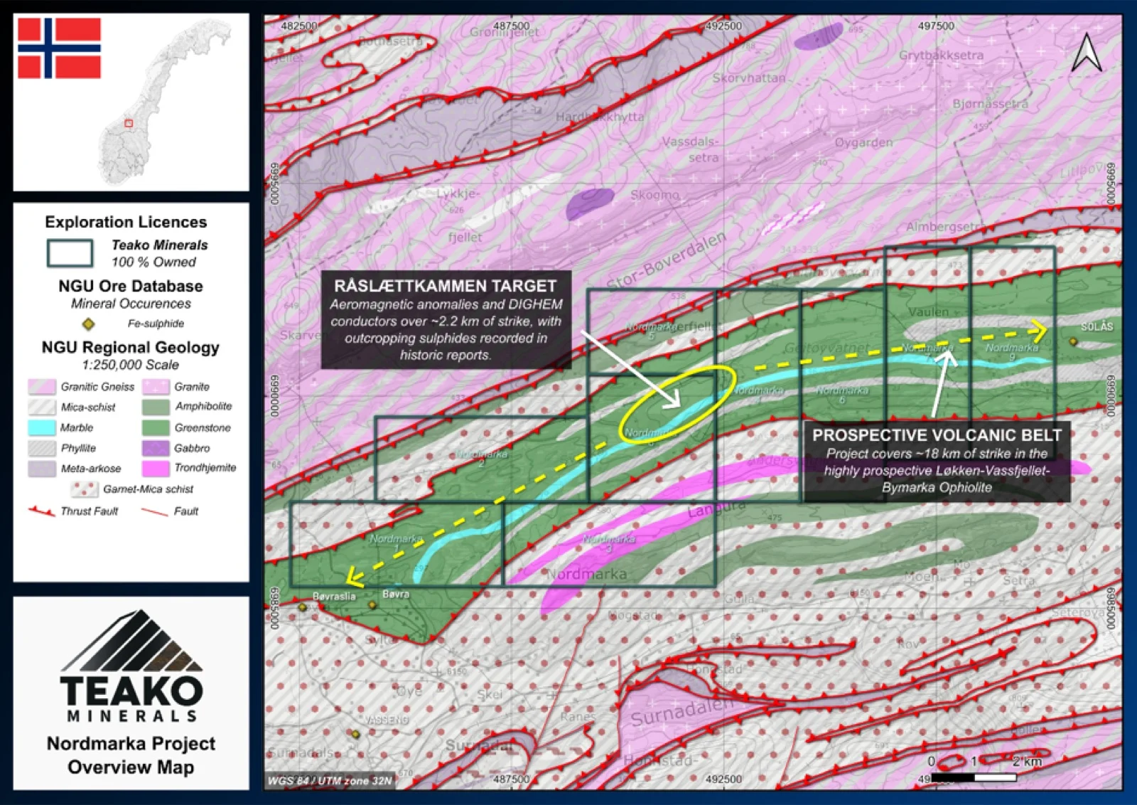
Teako’s 100% owned Nordmarka Project covers 85 km2 and is located in Møre og Romsdal about 40-50 km west of the Løkken deposit, covering the western continuation of the Løkken–Vassfjellet–Bymarka (LVB) ophiolite. The stratigraphy comprises a lower sedimentary unit (phyllites, quartzites), followed by schistose greenstones, overlain by massive greenstones, and finally the upper sediments (phyllites, limestones). The area is folded into an overturned isoclinal synform, with both limbs dipping to the south. Mineralization occurs as disseminations of pyrite and pyrrhotite, occasionally reaching massive sulphide.
Nordmarka benefits from a wealth of historical data. During the 20th century, Orkla Industrier AS conducted extensive regional campaigns over the LVB ophiolite (Logn and Brækken, 1953). This work included 16 near-vertical diamond drillholes that successfully identified magnetic pyrite mineralization. While the original drill logs are unavailable, the historical grid has been digitized, allowing these drill collars to be integrated directly into modern GIS platforms for precise targeting.
Future exploration will leverage knowledge from the Løkken VMS project, prioritizing field prospecting around mapped drill collars. Modelling of the hinges of the synform and mapping of conductive trends will focus targeting, while LGC and spectral sampling of volcanic stratigraphy will support comparisons to Løkken.
{{fig:1}}
1Teako has not performed sufficient work to verify the published data reported above, but the Company believes this information to be considered reliable and relevant. Results reported are maximum values and may not be representative of all samples collected within the area being evaluated
2References made to nearby mines and analogous deposits provide context for the regional targets but are not necessarily indicative that these targets host similar tonnages or grades of mineralization.
References
BV1929: Logn et al. (1953). Geofysiske undersøkelser Nordmarka – Surna, Surnadal.
References to the ‘NGU’ regard the ‘Norwegian Geological Survey’, in particular, their Resource Database and are consolidated under this citation for simplicity. For all data sourced from this resource, please refer to: https://geo.ngu.no/kart/mineralressurser_mobil/?lang=eng
Exploration-stage project. Any historical production, grades or estimates quoted in project descriptions are historical in nature, have not been verified by the Company as current mineral resources or reserves, and should not be relied upon. See the cautionary statements and the Qualified Person statement.