


The Løkken Ophiolite Project covers more than 260 km² across three licence clusters in Trøndelag, taking its name from the slice of ancient oceanic crust that hosted the historic Løkken mine.
More than 260 km² across three licence clusters on the Løkken Ophiolite: the geological unit that hosts the largest known Cyprus-type VMS deposit in the world. The historic Løkken Mine produced 24 Mt of ore at 2.3% Cu and 1.9% Zn with silver and gold credits1. Teako is targeting the same host horizon beyond the historically mined ground.
- Løkken West: a 6 km outcropping trend of massive Fe-sulphides and cherts, largely untested by drilling
- Brannåsen: ore-equivalent marker horizons with feeder-zone style alteration in their footwall
- Each cluster holds rocks correlating with the target Middle Volcanic Member (MVM) horizon
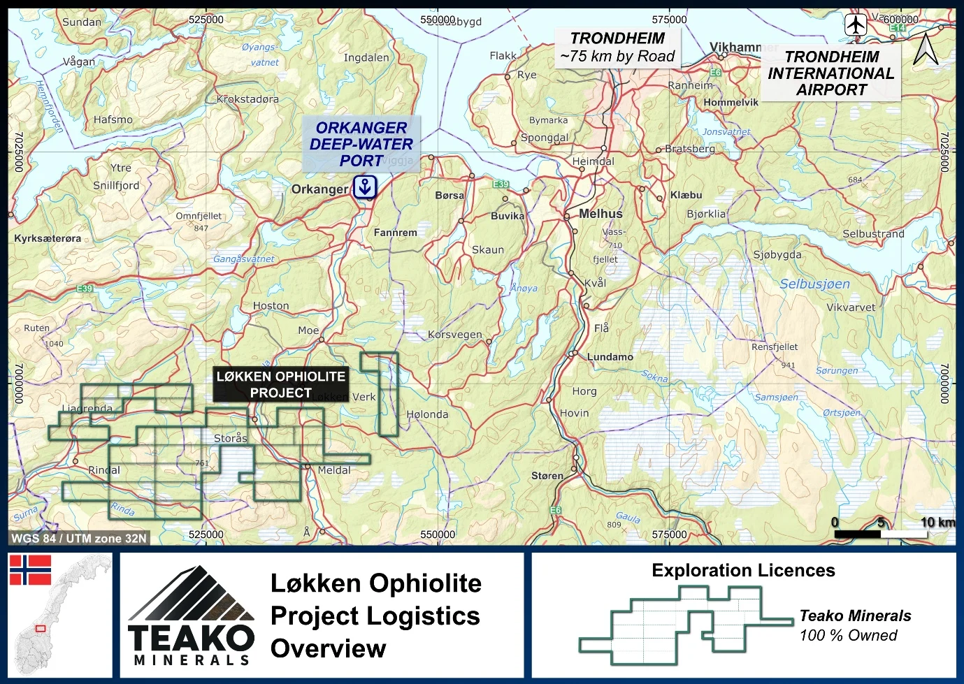
- Established infrastructure, including the Orkanger deepwater port
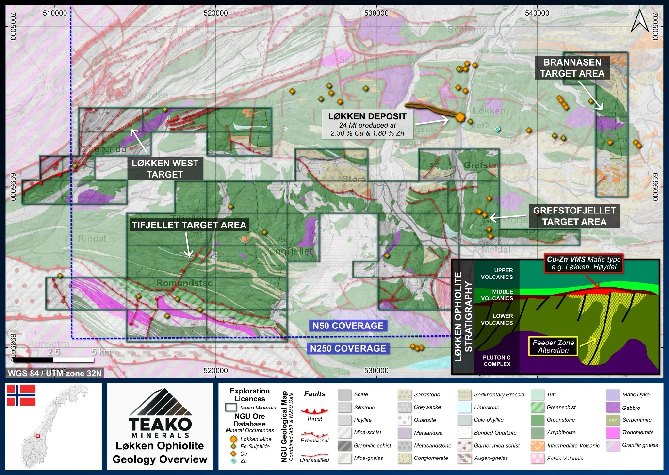
The project sits in Trøndelag county, central Norway. The Løkken Ophiolite is a slice of ancient oceanic crust formed in a back-arc basin roughly 481-489 million years ago, later thrust onto the continent during the Caledonian orogeny. Its volcanic rocks divide into three units; the middle unit, the Middle Volcanic Member, is the critical target position across the region (Grenne, 1989) and the host of the Løkken deposit itself.
{{fig:1}}
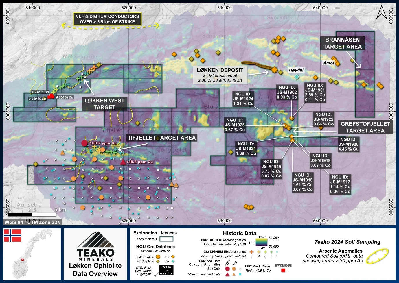
Each of the three licence clusters focusses on promising extensions of the ophiolite beyond the central area of historic mining and exploration around the Løkken Mine. Teako believes each area has the potential to host rocks correlating with the target MVM unit, an exciting search space for new Cu-Zn VMS discoveries similar to the Løkken deposit.2
{{fig:2}}
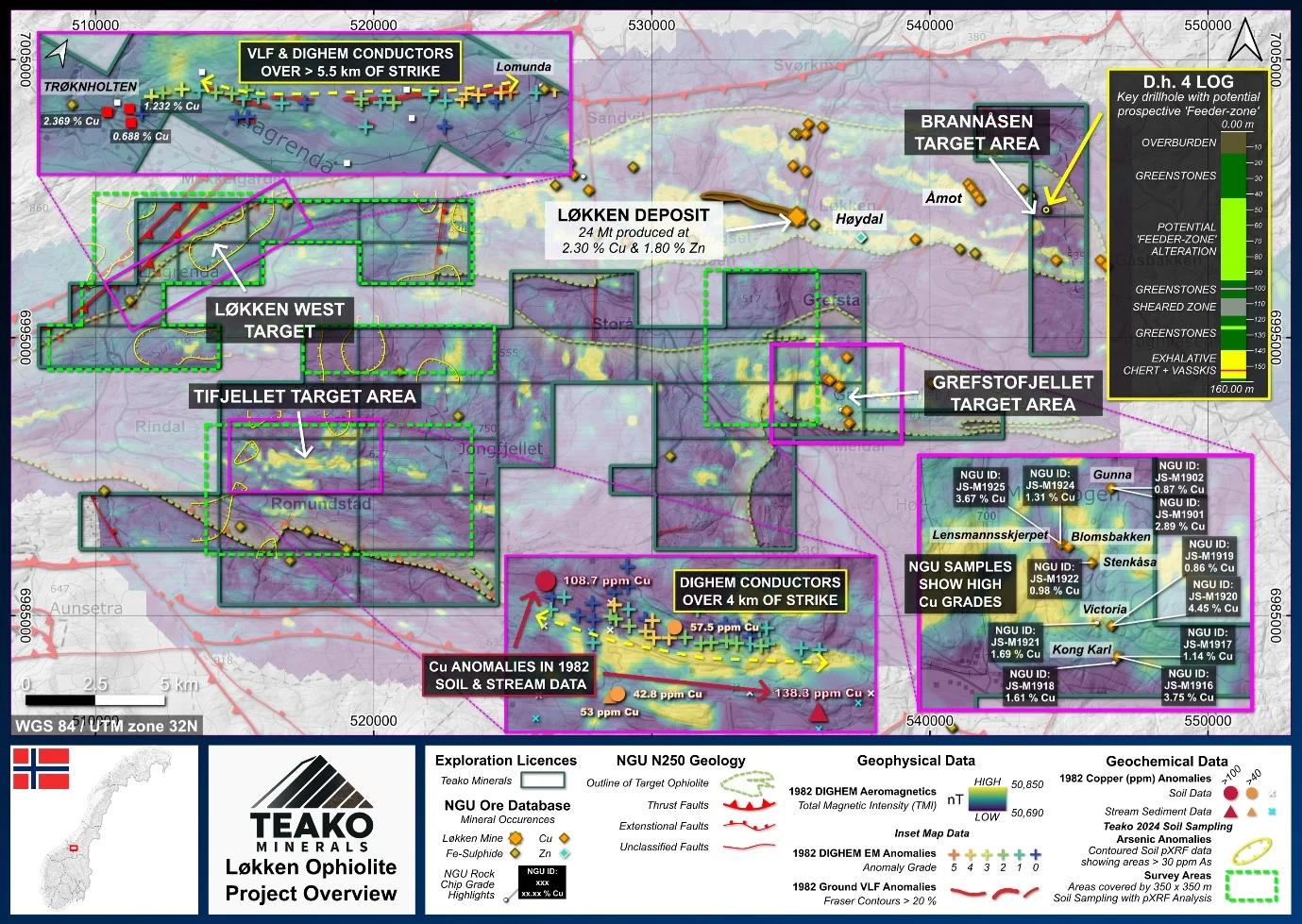
~20 km west of the Løkken mine: an outcropping trend of massive Fe-sulphides (locally termed Vasskis) and quartz-magnetite cherts traceable for over 6 km of strike, first picked up by helicopter geophysics in 1981. Samples from old trial workings in a valley crossing the southern end returned 1.23% and 2.37% Cu. Two drillholes at the far north-east end are the only test of the trend on record (Orkla Industrier AS, 1983).
In the north-east cluster, identified through a desktop review of historical data focussed on recorded hydrothermal alteration. Mapping, geophysics and four scout drillholes (703 m) in the early 1980s traced ore-equivalent marker horizons, cherts and vasskis, with feeder-zone style alteration in their stratigraphic footwall. Follow-up recommended around drillhole D.h.4 was never completed (Grenne, 1982).
As the strategy matures it extends across the wider project, to areas such as the historic copper mines of the Grefstofjellet target and the Tifjellet target, where historic geochemical and EM anomalies coincide.
{{fig:3}}
With Løkken West and Brannåsen, Teako has two areas on which an alteration-driven exploration strategy can be developed: mapping and quantifying alteration intensity with modern geochemical and spectral techniques, then deploying advanced geophysics and, subsequently, diamond drilling on the targets with the most promising geology.
{{fig:4}}
In-house geological mapping and prospect sampling to delineate areas of interest
Full geochemical analysis feeding sub-surface geophysics and firm drill targets for upcoming field seasons
1 Teako has not performed sufficient work to verify the published data reported above, but the Company believes this information to be considered reliable and relevant.
2 References made to nearby mines and analogous deposits provide context for the regional targets but are not necessarily indicative that these targets host similar tonnages or grades of copper mineralization.
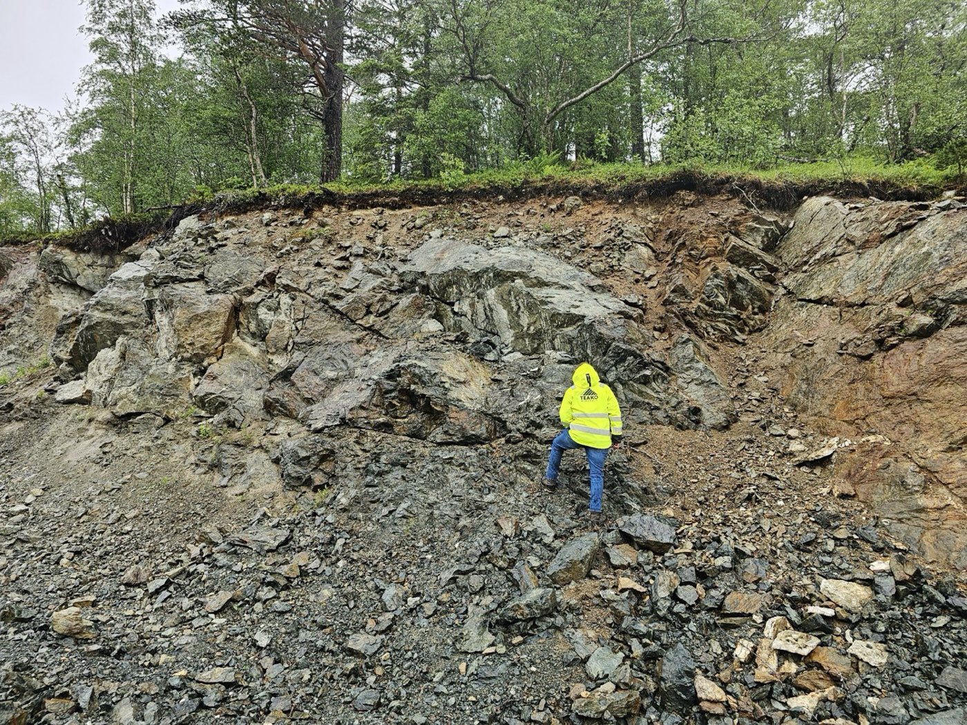
Field imagery
{{fig:5}}
{{fig:6}}
References
Grenne, T. (1982) BV1936 – Geological, geophysical and diamond drilling investigation in the Brannåsen area. LV 10. Orkla Industrier A/S, p. 22.
Grenne, T. (1989) ‘Magmatic evolution of the Lokken SSZ Ophiolite, Norwegian Caledonides: relationships between anomalous lavas and high-level intrusions’, Geological Journal, 24, pp. 251–274.
Orkla Industrier AS (1983) BV1812 – The Lomunda Area. Project Report LV 16. Orkla Industrier AS, p. 22.
References to the NGU Resource Database are consolidated under this citation for simplicity. For all data sourced from this resource, please refer to: https://geo.ngu.no/kart/mineralressurser_mobil/?lang=eng
Exploration-stage project. Any historical production, grades or estimates quoted in project descriptions are historical in nature, have not been verified by the Company as current mineral resources or reserves, and should not be relied upon. See the cautionary statements and the Qualified Person statement.