


126 km² in northern Trøndelag on the greenstones of the Norwegian Caledonides, hosting the Visletten occurrence (historical estimate 0.78 Mt at 0.92% Cu and 3.86% Zn), 22 km from the Joma VMS deposit.
Mykkelvika Project
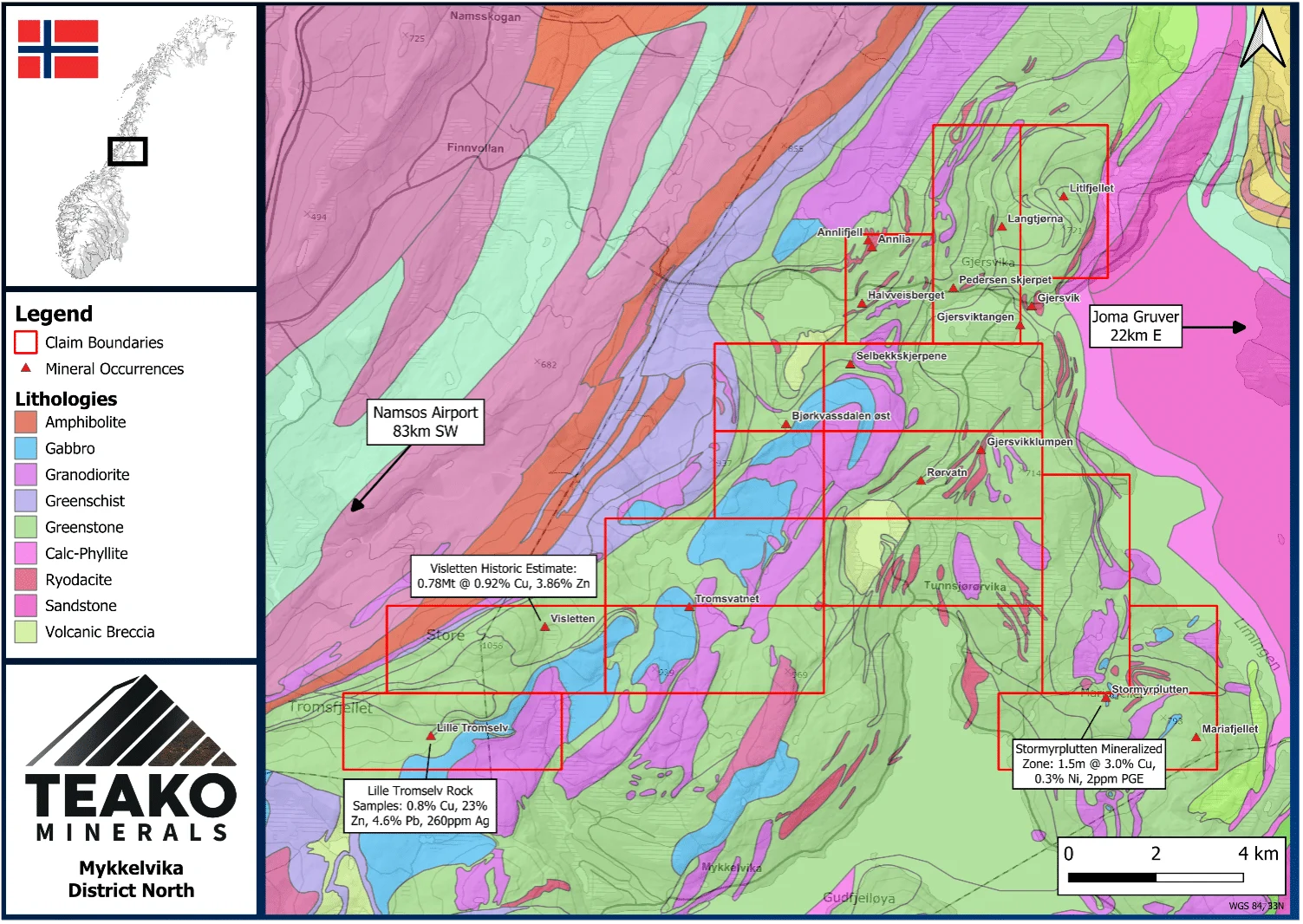
The Mykkelvika Project (see Figure 1) measures 126 km² in size and is located in the Namsskogan and Røyrvik municipalities in northern Trøndelag. The main highway (E6) runs parallel to the western side of the Project, and the Project is located 83 km northeast of the nearest airport in the city of Namsos.
The Project is situated within the highly prospective greenstone geology of the Norwegian Caledonides and hosts multiple mineral occurrences. These include the Visletten occurrence, which hosts a historical mineral estimate of (0.78 Mt @ 0.92% Cu and 3.86% Zn) (NGU, 2019)1 and the Lille Tromselv outcrop, where Norwegian Geological Survey (“NGU”) grab samples returned laboratory results of up to 0.8% Cu, 23% Zn, 4.6% Pb, and 260 ppm Ag2. These occurrences are located on the northern limb of an antiform, a structure encapsulated by the Project. Grab sampling undertaken by the NGU at Visletten returned laboratory results of up to 3.8% Cu and 17.0% Zn (Erris Resources, 2020)1,2.
The broader area also hosts several volcanogenic massive sulfide (“VMS”) occurrences, including the Joma deposit (historic production: 11.5 Mt @ 1.49% Cu and 1.45% Zn) (Bluelake Mineral, 2022) located approximately 22 km east of the Project3. The project area comprises a large, structurally complex and geologically prospective region with multiple known occurrences both within and surrounding the Project. In addition, the recently granted zoning plan for the Joma deposit further indicates the region is highly favourable for continued exploration and potential future mining activity. This is also supported by an overwhelming approval of the local population for mining activities, with the municipality of Røyrvik being an active member of the ”Mineral Nettverk” in Trøndelag, a collaboration of exploration companies, municipalities and other local stakeholders to revitalize the historic mining region.
1The Company has not undertaken sufficient work to independently verify either the historic estimates or production figures being reported but believes that the figures being reported are reliable and relevant to the overall project descriptions.
2Grab samples are select samples and may not be representative of mineralization located on the property.
3Mineralization hosted on adjacent and nearby properties is not necessarily indicative of mineralization that may be hosted on the Company’s projects.
{{fig:1}}
Exploration-stage project. Any historical production, grades or estimates quoted in project descriptions are historical in nature, have not been verified by the Company as current mineral resources or reserves, and should not be relied upon. See the cautionary statements and the Qualified Person statement.