


Mo project of roughly 10.0 km² in Northern Norway.
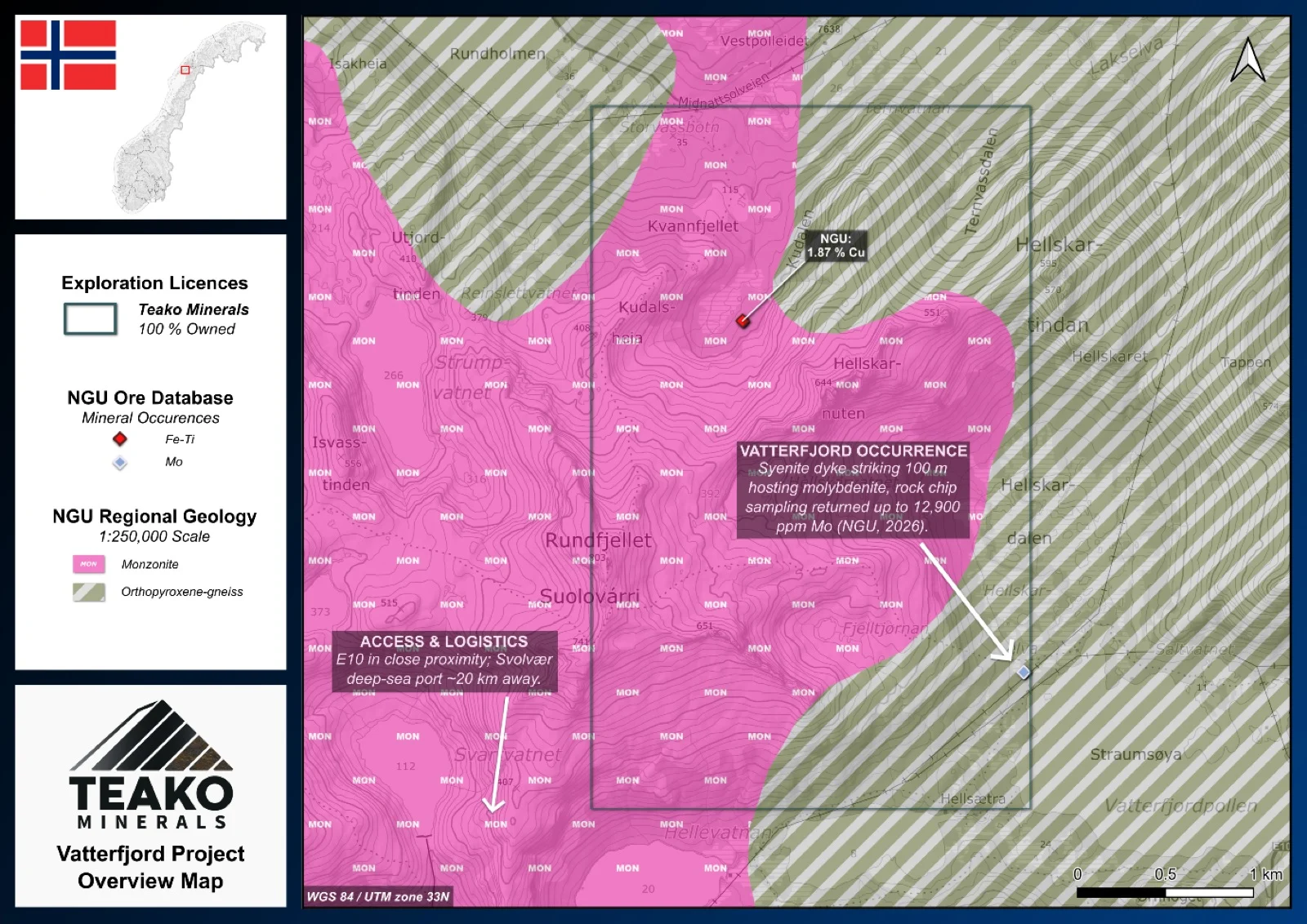
Teako’s 100% owned Vatterfjord Project is situated in the Lofoten archipelago, northern Norway, about 6 km north of Svolvær. The licence area covers 10 km2 and benefits from excellent infrastructure, with the E10 highway nearby and proximity to the coast for shipping. The project includes the historic Vatterfjord Mo occurrence, which was trial mined between 1915 and 1918 and is easily accessible via a hiking trail2.
Geologically, the area lies within the Paleoproterozoic Lofoten–Vesterålen Complex, featuring gneisses and the AMCG igneous suite, and is bounded to the east by Caledonian thrust nappes. Mineralization occurs in a north–south striking syenite dyke or lens, 15–20 m thick and hosted by fine- to medium-grained granite (Bergh et al. 2012). Molybdenite is the primary mineral, occurring as coarse flakes along fractures and within pegmatites, with minor pyrrhotite and chalcopyrite. NGU sampling returned grades of up to 12,900 ppm Mo (NGU ore database)1. About 2.5 km northwest, the historic Kudalen mine hosts massive magnetite in both coarse-grained granite and quartz-rich granitic gneiss2. A sample collected by the NGU also returned 1.87 % Cu1. To date, the area remains poorly explored; however, the significant molybdenum and copper grades observed at Vatterfjord warrant more detailed investigation.
{{fig:1}}
1Teako has not performed sufficient work to verify the published data reported above, but the Company believes this information to be considered reliable and relevant. Results reported are maximum values and may not be representative of all samples collected within the area being evaluated
2References made to nearby mines and analogous deposits provide context for the regional targets but are not necessarily indicative that these targets host similar tonnages or grades of mineralization.
References
Bergh et al. (2012) Was the Precambrian Basement of Western Troms and Lofoten-Vesterålen in Northern Norway Linked to the Lewisian of Scotland? A Comparison of Crustal Components, Tectonic Evolution and Amalgamation History.
References to the ‘NGU’ regard the ‘Norwegian Geological Survey’, in particular, their Resource Database and are consolidated under this citation for simplicity. For all data sourced from this resource, please refer to: https://geo.ngu.no/kart/mineralressurser_mobil/?lang=eng
Exploration-stage project. Any historical production, grades or estimates quoted in project descriptions are historical in nature, have not been verified by the Company as current mineral resources or reserves, and should not be relied upon. See the cautionary statements and the Qualified Person statement.