


Sedex-style Cu-Zn-Pb project of roughly 15.5 km² in Northern Norway.
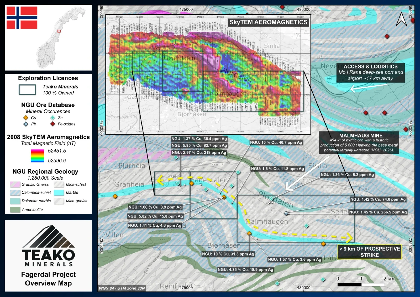
Teako’s 100% owned Fagerdal Project covers 16 km2 and is located in the Plurdalen valley, 15 km east of Mo i Rana, Nordland, with good access and nearby infrastructure, including the E6 highway, port facilities, a railway line, and airports. The project hosts the historic Malmhaug Mine, a skarn-related pyrite occurrence with estimated historic production of ~5,600 t of ore (NGU ore database)1,2. The ore is dominated by pyrite with accessory pyrrhotite, chalcopyrite, and sphalerite; copper and zinc enrichments occur locally. Geologically, the area belongs to the Plurdal Group within the Rana ore field, consisting of calcareous schists, marbles, amphibolites, and gneisses. The mineralization occurs in a 20–30 m transitional zone between gneiss and impure calcite marble, forming both disseminated sulphides and massive lenses up to several metres thick (Olerud, 1979 and Vik 1978). The lithological sequence is folded into an isoclinal synform with a dolomite core and generally dips 30–60° S–SW. Exploration history during the 20th century includes several phases of mapping, geophysics, and 17 drill holes delineating about 494 kt of pyritic ore. Ultimately, a 2008 SkyTEM airborne survey revealed a magnetic anomaly striking for several kilometres across the licence area, which has not yet been followed up on.
{{fig:1}}
1Teako has not performed sufficient work to verify the published data reported above, but the Company believes this information to be considered reliable and relevant. Results reported are maximum values and may not be representative of all samples collected within the area being evaluated
2References made to nearby mines and analogous deposits provide context for the regional targets but are not necessarily indicative that these targets host similar tonnages or grades of mineralization.
References
BV1545: Olerud (1979). Stratabound skarn med koppermineralisering i Plurdalen, Rana.
BV3936: Vik (1978). Geologiske undersøkelser ved Malmhaugen kisforekomst og bly-sink skjerp, Rana.
BV10086: SkyTEM Aps (2008). SkyTEM Survey Mo i Rana, Area3 – Norway Data report.
References to the ‘NGU’ regard the ‘Norwegian Geological Survey’, in particular, their Resource Database and are consolidated under this citation for simplicity. For all data sourced from this resource, please refer to: https://geo.ngu.no/kart/mineralressurser_mobil/?lang=eng
Exploration-stage project. Any historical production, grades or estimates quoted in project descriptions are historical in nature, have not been verified by the Company as current mineral resources or reserves, and should not be relied upon. See the cautionary statements and the Qualified Person statement.