


Hydrothermal-style Cu project of roughly 105.7 km² in Northern Norway.
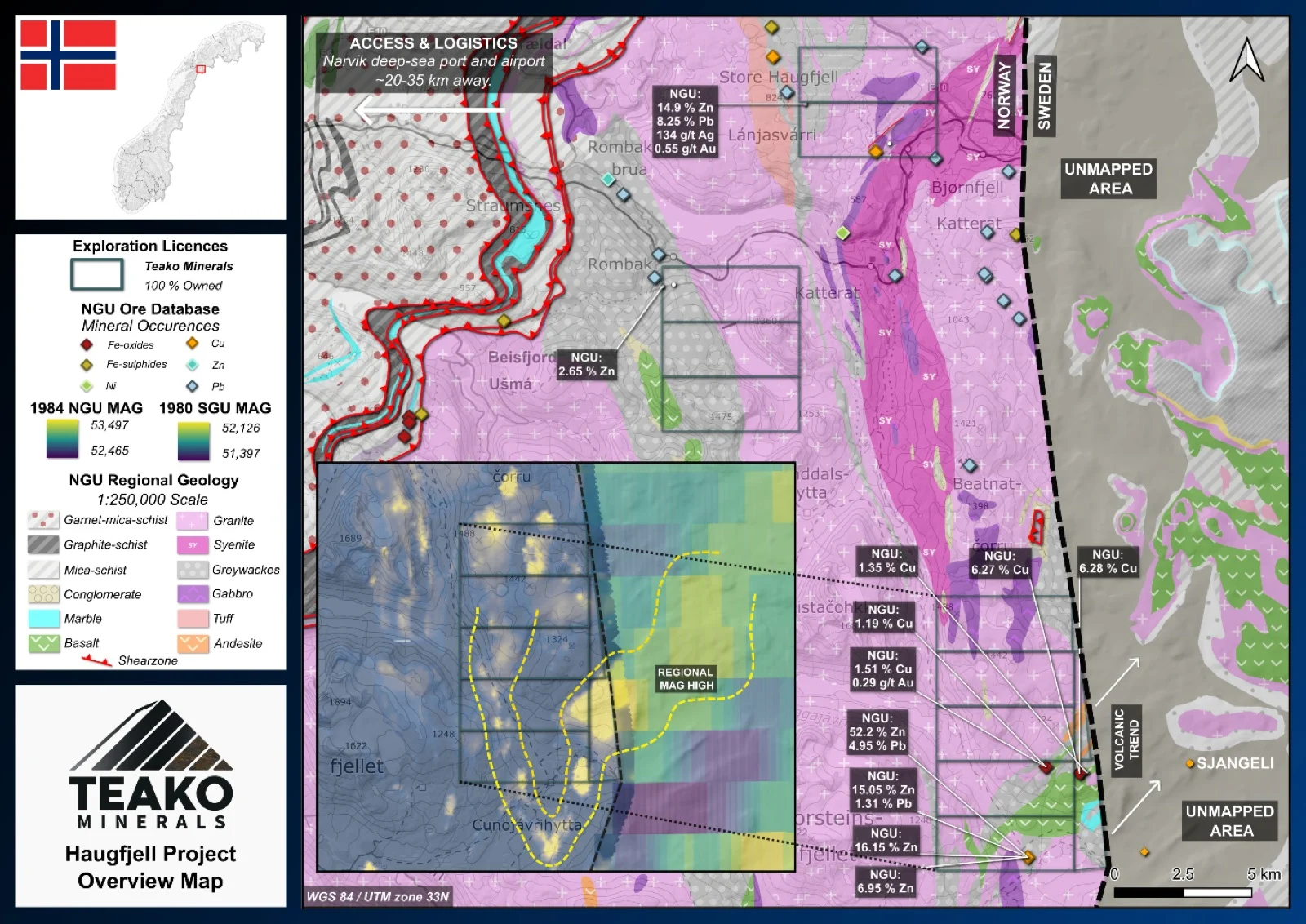
The Haugfjell project is a 100% owned early-stage greenfield exploration project covering 106 km2 in Narvik, Nordland, and geologically situated within the Rombaks Precambrian Window. Teako Minerals is currently evaluating the property for both base and precious metal mineralization.
Exploration currently focuses on three primary target areas:
Rosokkatoppen: This is considered the most prospective target area due to its potential geological continuity with the high-grade Sjangeli copper occurrence in neighboring Sweden. Historic stream sediment sampling extending from Rosokkatoppen to Doaresvarre identified copper anomalies equal to or greater than those observed at Sjangeli. Furthermore, localized historical rock sampling of pyrrhotite-chalcopyrite mineralization returned copper grades up to 0.84% (Band, 1976)1.
Varden East: A confirmed base metal and gold target where historical 1980s exploration identified gold mineralization over a 400-meter strike length associated with graphite-bearing units. Historic chip sampling of quartz-carbonate veins within this zone returned anomalous gold values reaching up to 1,540 ppb (Boye et al., 1989)1.
Hunddalen: While it remains the least explored of the target areas, historic sampling indicates clear mineralization potential. During a 1980s exploration campaign involving 112 samples1, one sample returned 1.7% combined zinc and lead, and another yielded gold values exceeding 100 ppb (Boye et al., 1989).
The main objective for Teako is to deploy modern exploration methods to determine if the Rosokkatoppen and Sjangeli mineralized zones are geologically linked. Current efforts are focused on a desk-based reconciliation of historic geological mapping discrepancies between the Norwegian and Swedish geological surveys.
{{fig:1}}
1Teako has not performed sufficient work to verify the published data reported above, but the Company believes this information to be considered reliable and relevant. Results reported are maximum values and may not be representative of all samples collected within the area being evaluated
References
Band, R.B. (1971). Investigations in the Rosokkatoppen Sjangeli area. BV446.
Band, R.B. (1976). Prospekteringsarbeid i Rosokkatoppen-kobberfelt, Nordland 1976. BV7343.
Boye, Ø., et al. (1989). Sampling for Gold at Varden East and Hunddalsbotn, The Rombak Project, North-Norway. BV7267.
References to the ‘NGU’ regard the ‘Norwegian Geological Survey’, in particular, their Resource Database and are consolidated under this citation for simplicity. For all data sourced from this resource, please refer to: https://geo.ngu.no/kart/mineralressurser_mobil/?lang=eng
Exploration-stage project. Any historical production, grades or estimates quoted in project descriptions are historical in nature, have not been verified by the Company as current mineral resources or reserves, and should not be relied upon. See the cautionary statements and the Qualified Person statement.