


TIB2 granite-gneisses-style U-Th-REE project of roughly 356.0 km² in Northern Norway.
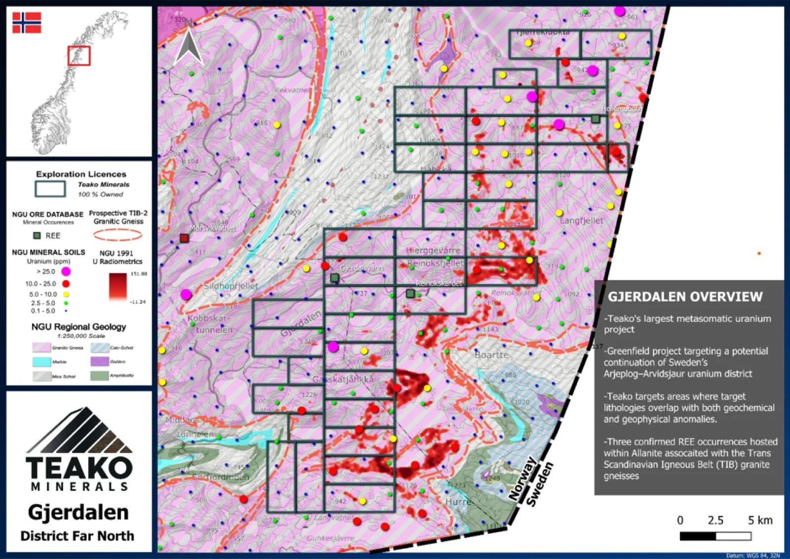
Teako’s 100% owned Gjerdalen project covers an area of TIB-2 granite and is an important strategic area in the Tysjford region, totalling 356 km². This project benefits from full coverage of the NGU datasets and contains some of the most consistent soil geochemistry anomalies in the Tysfjord area. Two REE occurrences have also been identified on the project by the NGU and present an additional resource opportunity to complement any uranium resources1.
Geochemistry data from the NGU has been utilised by the technical team to highlight the north and south of the project as initial targets for further exploration. Two areas, Hellembotn and Gjerdalsvatn, with significant REE mineralization have previously been identified by the NGU within the project, both possessing abundant, REE bearing allanite (which exhibits elevated niobium values) and other REE-Zr-Th-U bearing accessory minerals. A common feature of both occurrences is the presence of fine-grained, gneissic dykes exhibiting elevated REE values and radiometric anomalies. Initial REE tonnages were also estimated by the NGU with Gjerdalsvatn hosting 150,000t and Hellembotn containing 600,000t2.
The Gjerdalen project covers a wide area of prospective ground, with both REE and Uranium potential. Teako sees this Gjerdalen as a compelling project for more detailed exploration, with mapping and geochemical studies assisting in refining targets for drilling.
{{fig:1}}
1Teako has not performed sufficient work to verify the published data reported above, but the Company believes this information to be considered reliable and relevant. Results reported are maximum values and may not be representative of all samples collected within the area being evaluated
2References made to nearby mines and analogous deposits provide context for the regional targets but are not necessarily indicative that these targets host similar tonnages or grades of mineralization.
References
References to the ‘NGU’ regard the ‘Norwegian Geological Survey’, in particular, their Resource Database and are consolidated under this citation for simplicity. For all data sourced from this resource, please refer to: https://geo.ngu.no/kart/mineralressurser_mobil/?lang=eng
Exploration-stage project. Any historical production, grades or estimates quoted in project descriptions are historical in nature, have not been verified by the Company as current mineral resources or reserves, and should not be relied upon. See the cautionary statements and the Qualified Person statement.