


VMS-style Cu-Zn project of roughly 56.0 km² in Central Norway.
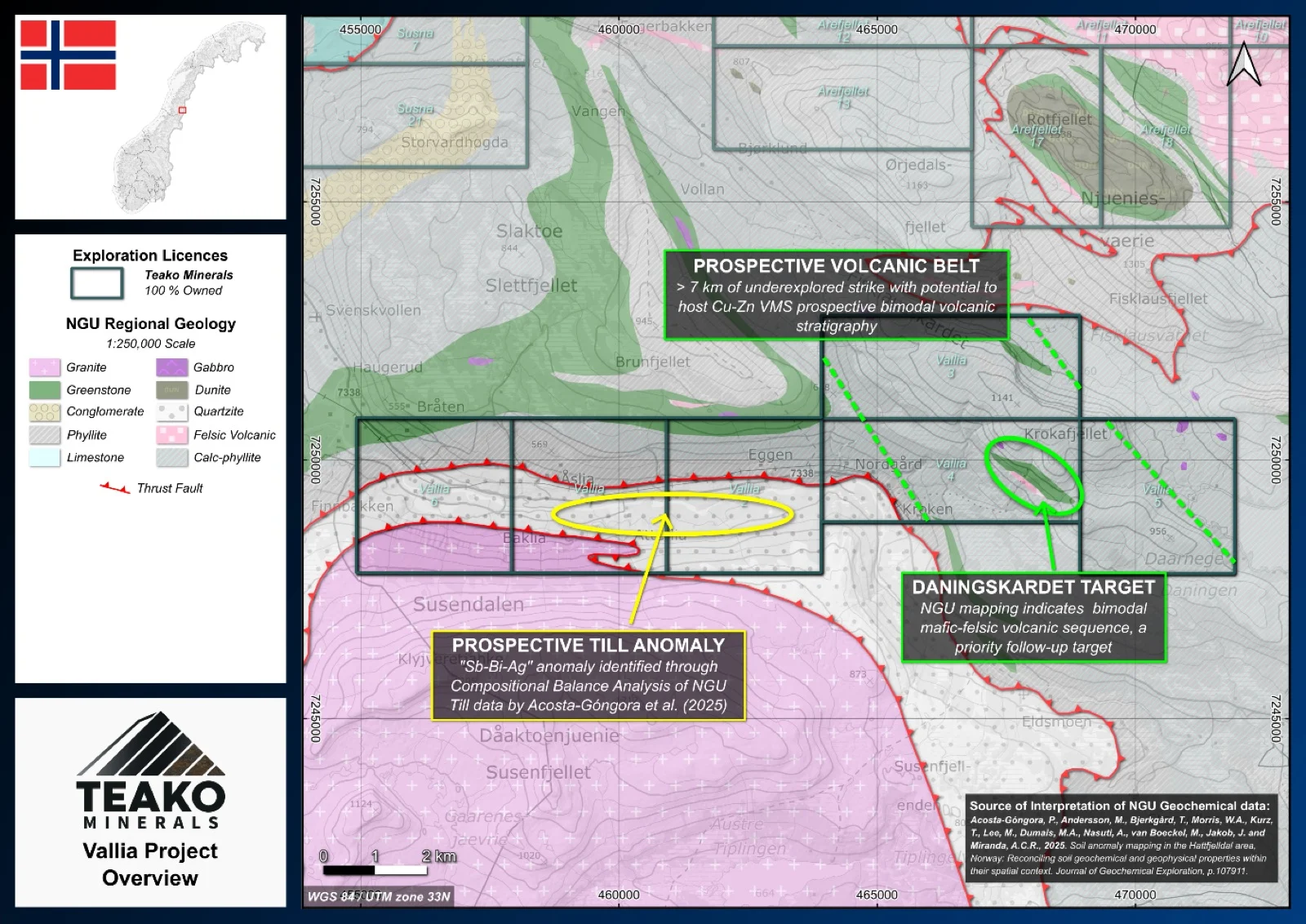
The 100% owned Vallia licence area spans 56 km2 and is part of Teako’s Hattfjelldal cluster about 10 km south of the Arefjellet project. The project covers two main geological packages: quartzites between two major NGU-mapped shear zones in the west, corresponding to a Sb-Bi-Pb geochemical anomaly, and a calc-phyllite dominant package of the Upper-Middle Koli Nappe in the east. Of particular interest is the potential continuation into Norway of the Stekenjokk Keratophyres, mapped just across the border in Sweden, with the NGU mapping a felsic volcanic unit within the Vallia area that may represent this extension. The mapped geology indicates that this highly prospective package should continue over into Norway. It is possible that a previously unmapped extension of the Stekenjokk belt continues through into the Vallia licence area.
Initial work should focus on detailed mapping of the NGU-identified felsic volcanics, supported by lithogeochemical and geochronological sampling. Testing the theories of geological extension of the prospective units from Sweden. This dataset will also provide context for other regional targets, contributing to the understanding of the metallogenic framework of the region.
{{fig:1}}
1Teako has not performed sufficient work to verify the published data reported above, but the Company believes this information to be considered reliable and relevant. Results reported are maximum values and may not be representative of all samples collected within the area being evaluated
2References made to nearby mines and analogous deposits provide context for the regional targets but are not necessarily indicative that these targets host similar tonnages or grades of mineralization.
References
Acosta-Gongora et al. (2024). Ore Geology Reviews. A multi-domain approach for soil geochemical anomaly mapping: a case study from the Hattfjelldal area, Norway. Manuscript Draft.
References to the ‘NGU’ regard the ‘Norwegian Geological Survey’, in particular, their Resource Database and are consolidated under this citation for simplicity. For all data sourced from this resource, please refer to: https://geo.ngu.no/kart/mineralressurser_mobil/?lang=eng
Exploration-stage project. Any historical production, grades or estimates quoted in project descriptions are historical in nature, have not been verified by the Company as current mineral resources or reserves, and should not be relied upon. See the cautionary statements and the Qualified Person statement.