


Graphite hosted-style U-Th-REE project of roughly 6.0 km² in Northern Norway.
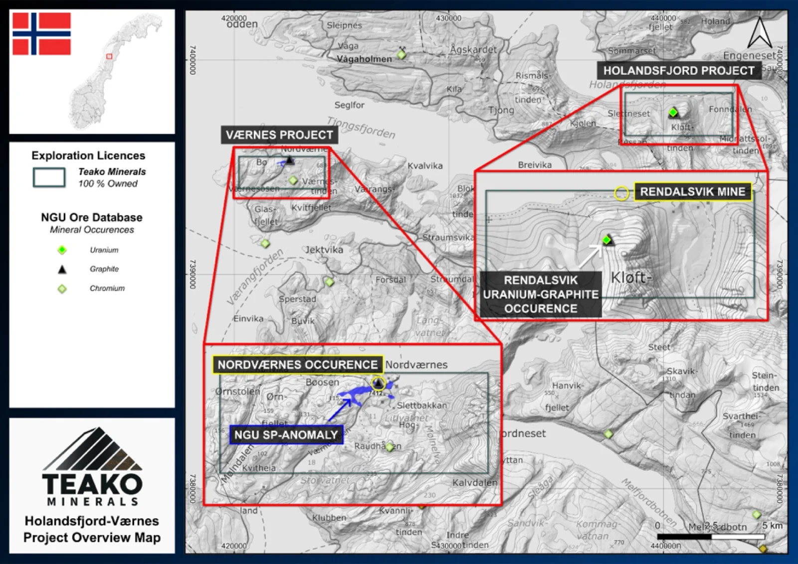
The Holandsfjord-Værnes Projects consists of two licence areas in the Meløy and Rødøy Municipalities of Nordland County, covering 10 km2 and 8 km2 respectively.
The Holandsfjord Project is focussed on graphite-bearing metamorphic rocks in and around the historic Rendalsvik Mine. The potential for Uranium in these rocks was identified in the 1950s, and after several field programmes 2.3 Mt of U-bearing graphite schist was estimated across two main deposits (Neuman, 1952; Føyn, 1953)1,2. Later exploration in the 1980s involved 866 m of diamond drilling across 14 holes, and during this programme a composite sample analysed by the NGU returned grades of 9.5 % C, 388 ppm V, 36 ppm U and 10 ppm Th with an Fe-sulphide content of ~5 % (Skofteland and Vestereng, 1984)1. In 2014 the NGU performed a geophysical inversion of their helicopter electromagnetics for the deposit area which indicated continuous good conductors. The airborne EM-data indicates the best conductive material in the area between the historical drilling and the mine workings, at an estimated depth of ~100 m (Rønning et al., 2014).
The Værnes claim is also focussed on graphitic schists, which have been mined historically at several localities, the largest being an open-cut that measures ~ 60 m long, ~3 m deep and up to ~3 m wide (Rønning et al., 2014). Graphite mineralization occurs as lenses and layers within the host mica-gneisses, generally reaching thicknesses of 1.5 – 2.0 m.
The geological analogue for the U-bearing graphitic schists at Holandsfjord and Værnes would be the Alum shales of Sweden, such as the Viken deposit2. As exploration for Uranium on these claims will be focussed on graphitic rocks, ground electromagnetics across and along strike of known localities and anomalies will be a priority, in addition to ground radiometric surveys.
{{fig:1}}
1Teako has not performed sufficient work to verify the published data reported above, but the Company believes this information to be considered reliable and relevant. Results reported are maximum values and may not be representative of all samples collected within the area being evaluated
2References made to nearby mines and analogous deposits provide context for the regional targets but are not necessarily indicative that these targets host similar tonnages or grades of mineralization.
References
Føyn, S. (1953) Rendalsvik graphite deposit. Technical Report BA4683. NGU.
Neuman, H. (1952) Dagbok fra Nord-Norge. Bergarkivrapport BA7709.
Rønning, J.S. et al. (2014) Oppfølgende grafittundersøkelser i Meløy og Rødøy kommuner, Nordland. NGU Report 2014.046. Trondheim: NGU, p. 64.
Skofteland, H. and Vestereng, V. (1984) BV3585 – Undersøkelser Rendalsvik sommeren 198. Norwegian Talc A/S.
References to the ‘NGU’ regard the ‘Norwegian Geological Survey’, in particular, their Resource Database and are consolidated under this citation for simplicity. For all data sourced from this resource, please refer to: https://geo.ngu.no/kart/mineralressurser_mobil/?lang=eng
Exploration-stage project. Any historical production, grades or estimates quoted in project descriptions are historical in nature, have not been verified by the Company as current mineral resources or reserves, and should not be relied upon. See the cautionary statements and the Qualified Person statement.