


Aplite-style U-Th-REE project of roughly 110.6 km² in Northern Norway.
The 100% owned Svarthola project covers 111 km2 and is located in the Nordland province of Norway. The project encompasses the Harelifjell deposit, which is notable for being one of only two recognized uranium deposits in Norway (non-compliant)2. In addition to uranium, molybdenum occurrences have also been recorded within the south-western extent of the license blocks.
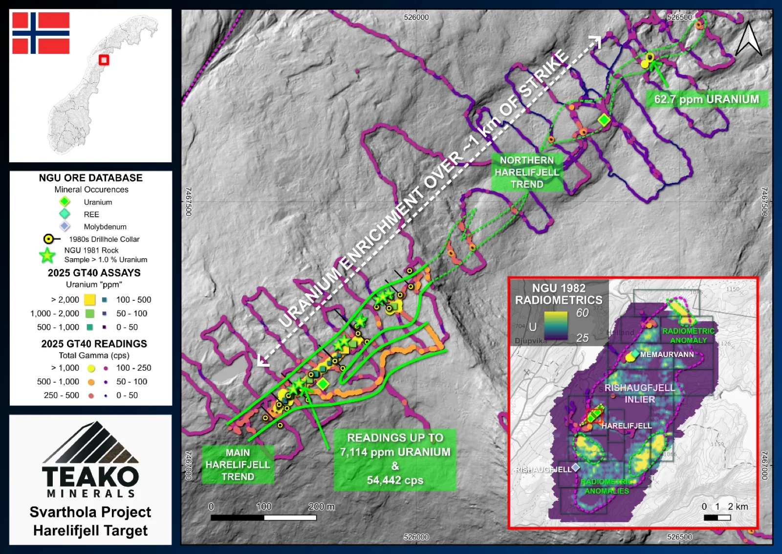
Uranium mineralization at Harelifjell primarily forms in irregular zones within an aplite body that intrudes the local Rishaugfjell gneiss. The primary uranium-bearing mineral present is uraninite. This mineralized aplite can be tracked for up to 1.4 kilometers along a northeast-southwest trend, returning historic grades of up to 5% uranium (Lindhal, 1984)1. The main mineralized zone consists of fracture zones containing narrow, dark biotite-uraninite mineralization that varies in thickness from 1 millimeter up to 30 centimeters.
Historical exploration of the deposit by the Norwegian Geological Survey (NGU) in the early 1980s included two drilling campaigns. This comprised an 80-meter pacsac drill program in 1981, followed by an 835.4-meter diamond drilling program in 1982. Minor excavation work was also conducted to depths of 20 to 30 meters during this period. Historical 1979/1980 NGU stream sediment sampling revealed positive enrichment in uranium and molybdenum (a common pathfinder element) in a separate catchment1. This placement could suggest the presence of a separate, undiscovered uranium source beyond the main Harelifjell deposit.
Teako completed a phase one field program in the summer of 2025 to characterize the mineralization, resample known zones, and map associated radiometric anomalies. Elevation differences in the northern Harelifjell zone suggest the potential for deeper, continuous mineralization. Furthermore, airborne radiometric surveys indicate that the Harelifjell mineralization could extend approximately 5 kilometers to the south. The initial results of this have indicated that further exploration work across the licence area is warranted. to fully assess the potential of this project.
{{fig:1}}
1Teako has not performed sufficient work to verify the published data reported above, but the Company believes this information to be considered reliable and relevant. Results reported are maximum values and may not be representative of all samples collected within the area being evaluated
2References made to nearby mines and analogous deposits provide context for the regional targets but are not necessarily indicative that these targets host similar tonnages or grades of mineralization.
References
Lindahl, I. (1984) Rishaugfjellvinduet og Harelifjell uranmineralisering. Sørfold, Nordland. NGU Report 84.057. NGU.
References to the ‘NGU’ regard the ‘Norwegian Geological Survey’, in particular, their Resource Database and are consolidated under this citation for simplicity. For all data sourced from this resource, please refer to: https://geo.ngu.no/kart/mineralressurser_mobil/?lang=eng
Exploration-stage project. Any historical production, grades or estimates quoted in project descriptions are historical in nature, have not been verified by the Company as current mineral resources or reserves, and should not be relied upon. See the cautionary statements and the Qualified Person statement.