


Skarn-style Cu-Au-Ag project of roughly 18.0 km² in Northern Norway.
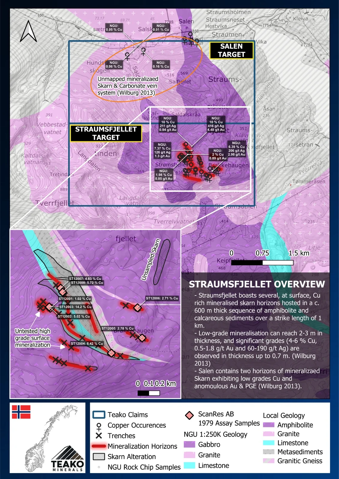
Teako’s 100% owned Straumsfjellet Project covers 18 km2 and is a high-grade polymetallic Cu-Au-Ag Skarn project located in Kvæfjord Municipality in northern Norway. The mineralization has been identified at the Straumsfjellet occurrence within a suite of gabbro, mica schist, and granite, interpreted as allochthonous supracrustal rocks of possible Precambrian age. The occurrence was first identified in 1900 and has since been explored through geological mapping, trenching, rock sampling, and geophysical surveys, including electromagnetic and magnetic investigations (Often, 1978). The mineralization is primarily associated with skarn alteration developed in calcareous metasedimentary rocks, where it occurs as small but high-grade lenses.
The dominant ore minerals include bornite, chalcocite, and chalcopyrite, with minor pyrrhotite. Rock sampling has returned copper grades ranging from 1 % to 4 %, with an average of about 2.3 % Cu1. Silver values range from 10 to 131 ppm, averaging 61 ppm Ag (NGU ore database)1. Overall, the occurrence represents a high-grade skarn system, warranting further detailed geological and geochemical investigation to better define its extent and economic potential.
{{fig:1}}
1Teako has not performed sufficient work to verify the published data reported above, but the Company believes this information to be considered reliable and relevant. Results reported are maximum values and may not be representative of all samples collected within the area being evaluated
2References made to nearby mines and analogous deposits provide context for the regional targets but are not necessarily indicative that these targets host similar tonnages or grades of mineralization.
References
Often, B. V. (1978). Geologisk undersøkelse og VLF-målinger av Straumsfjell kobberforekomster.
Wilberg, R. (2013) Polymetallic mineralisations in Kvæfjord, Troms: Straumsfjellet, Salen and Kvæfjord (Berg Mine). Scandinavian Resources AB, January 2013.
References to the ‘NGU’ regard the ‘Norwegian Geological Survey’, in particular, their Resource Database and are consolidated under this citation for simplicity. For all data sourced from this resource, please refer to: https://geo.ngu.no/kart/mineralressurser_mobil/?lang=eng
Exploration-stage project. Any historical production, grades or estimates quoted in project descriptions are historical in nature, have not been verified by the Company as current mineral resources or reserves, and should not be relied upon. See the cautionary statements and the Qualified Person statement.