


Hydrothermal-style Au project of roughly 49.7 km² in Northern Norway.
The 100% owned Stortuva Project consists of six contiguous license blocks in the Vefsn Municipality in Nordland, covering approximately 49.7 km2. The project is located just southwest of the town of Mosjøen, and benefits from a highly developed and functional infrastructure, including roads, railways, deep-sea ports, hydro and wind power facilities, and nearby airports (see Figure 1).
The Stortuva Project covers part of the Upper Helgeland Nappe Complex, part of the Uppermost Allocthon of the Scandinavian Caledonides. The area is dominated by a package of gneisses, marbles and amphibolites of Cambrian-Ordovician age which were intruded by several phases of S-type granites of the Bindal Batholith from ~465 Ma through to 424 Ma during the Caledonian orogeny (Nordgulen et al., 1993; Barnes et al., 2007).
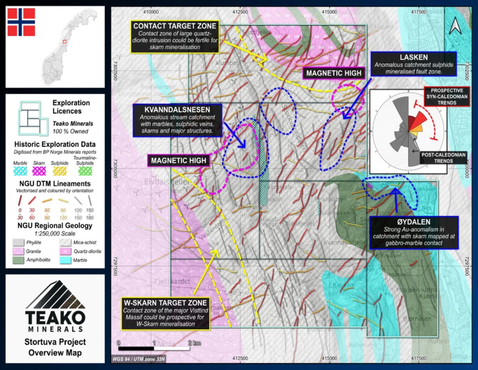
Exploration by BP Norge Minerals focussed on gold mineralization in the early 1980s. A stream sediment sampling dataset has been digitised from this era (BP Norge Minerals, 1983), with data recorded for Cu, Pb, Zn, As and W on topographic maps. Samples from the Øydalen catchment showing Au values of 308 ppb, 549 ppb and 857 ppb Au (BP Norge Minerals, 1982)1.
{{fig:1}}
Observations of marbles, sulphidic and tourmaline-filled fault zones and skarn development are all indicated in the project area. The recorded skarn development was observed in the Øydalen area which gives further indication of polymetallic potential over the project.
The Stortuva Project is considered prospective for Skarn mineralization related to the emplacement of Caledonian felsic intrusions into carbonate-bearing metasediments in the Helgeland Nappe Complex. In addition, there are Au-As veins and breccias across several occurrences around the Tosen fjord ~60 km to the south of the Stortuva Project, close to the Målvika W-skarn (Müller and Furuhaug, 2008)2. Therefore, this project hosts potential for multiple styles of mineralization making it a compelling target for modern exploration.
1Teako has not performed sufficient work to verify the published data reported above, but the Company believes this information to be considered reliable and relevant. Results reported are maximum values and may not be representative of all samples collected within the area being evaluated
2References made to nearby mines and analogous deposits provide context for the regional targets but are not necessarily indicative that these targets host similar tonnages or grades of mineralization.
References
BP Norge Minerals (1983) Helgeland Project 1983 Annual Report. Annual Report BV3460. BP Norge Minerals.
BP Norge Minerals (1982) Helgeland Project 1982 Annual Report. Annual Report BV3459. BP Norge Minerals.
Nordgulen, Ø. et al. (1993) ‘U-Pb zircon ages from the Bindal Batholith, and the tectonic history of the Helgeland Nappe Complex, Scandinavian Caledonides’, Journal of the Geological Society, 150(4), pp. 771–783. Available at: https://doi.org/10.1144/gsjgs.150.4.0771.
Müller, A. and Furuhaug, L. (2008) Resource evaluation of the Målvika tungsten deposit, Nordland. NGU Report 2008.008. NGU, Nordic Mining.
Barnes, C.G. et al. (2007) ‘Timing of sedimentation, metamorphism, and plutonism in the Helgeland Nappe Complex, north-central Norwegian Caledonides’, Geosphere, 3(6), p. 683. Available at: https://doi.org/10.1130/GES00138.1.
References to the ‘NGU’ regard the ‘Norwegian Geological Survey’, in particular, their Resource Database and are consolidated under this citation for simplicity. For all data sourced from this resource, please refer to: https://geo.ngu.no/kart/mineralressurser_mobil/?lang=eng
Exploration-stage project. Any historical production, grades or estimates quoted in project descriptions are historical in nature, have not been verified by the Company as current mineral resources or reserves, and should not be relied upon. See the cautionary statements and the Qualified Person statement.