


Cu, W, Bi project of roughly 18 km² in Central Norway.
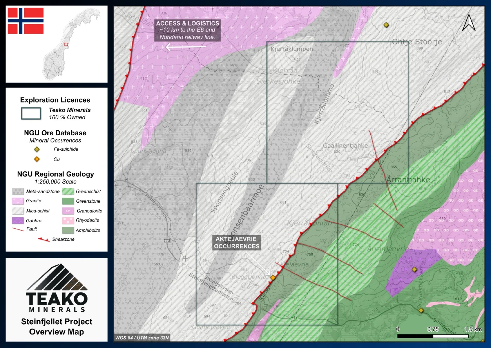
Teako’s 100% owned Steinfjellet base metal Project spans 18 km2 and hosts the Aktejaevrie base metal prospect in the Namsskogan area in northern Trøndelag. The project is easily accessible and was explored during the 1970s through soil geochemistry, SP and magnetic surveys following the discovery of chalcopyrite-bearing boulders (Logn, 1971).
The project lies across the boundary between the Køli and Helgeland nappe complexes, marked by a major northeast-southwest-trending shear-zone. The geology comprises amphibolites and greenstones of the Køli Nappe and mica-schists and meta-sandstones of the Helgeland Nappe, with local granitic intrusions.
The Aktejaevrie prospect is hosted within a gossan developed in graphite-bearing mica schists about 40 m west of the interpreted nappe contact. Mineralization consists of disseminated pyrrhotite, pyrite and locally chalcopyrite. Geochemical sampling has also returned elevated W (up to 472 ppm) together with anomalous Bi (NGU ore database)1.
Historic exploration identified a strong SP anomaly interpreted as a conductive graphite-bearing horizon, closely coincident with a magnetic anomaly. Soil geochemistry outlined a broad zone of anomalous copper values coincident with the geophysical anomalies. This therefore is likely a key exploration play to understand the links between the surface geochemical signatures and the deeper seated geophysical anomalies, to assess the potential for further base metal mineralization.
{{fig:1}}
1Teako has not performed sufficient work to verify the published data reported above, but the Company believes this information to be considered reliable and relevant. Results reported are maximum values and may not be representative of all samples collected within the area being evaluated
2References made to nearby mines and analogous deposits provide context for the regional targets but are not necessarily indicative that these targets host similar tonnages or grades of mineralization.
References
BV5274: Logn (1971). Grongprosjektet. Objekt 68 – Steinfjell rustsone. Geo-rekognosering.
References to the ‘NGU’ regard the ‘Norwegian Geological Survey’, in particular, their Resource Database and are consolidated under this citation for simplicity. For all data sourced from this resource, please refer to: https://geo.ngu.no/kart/mineralressurser_mobil/?lang=eng
Exploration-stage project. Any historical production, grades or estimates quoted in project descriptions are historical in nature, have not been verified by the Company as current mineral resources or reserves, and should not be relied upon. See the cautionary statements and the Qualified Person statement.