


Hydrothermal-style Au project of roughly 20 km² in Central Norway.
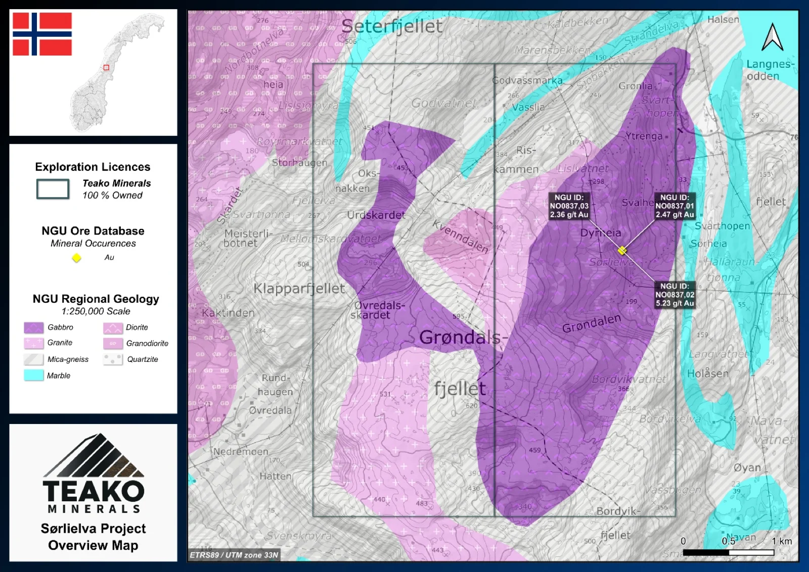
Teako’s 100% owned Sørlielva Project covers 20 km2 and is located in southern Nordland, approximately 12 km southeast of Brønnøysund, providing excellent infrastructure, including proximity to an airport, road access to the project site, and convenient shipping options. The licence area hosts the Sørlielva gold occurrence, which was discovered by BP Minerals during the 1980s as part of a broader gold exploration campaign across Nordland. The occurrence comprises a quartz-carbonate vein approximately 20–35 cm wide and exposed over a strike length of about 50 m. Pyrite is the principal sulphide mineral and occurs both as disseminations and as fracture fillings throughout the vein. The regional geology forms part of the Caledonian orogeny, specifically the Helgeland Nappe Complex. The mineralization is hosted by foliated diorite-gabbro intruded by granitic dykes. Rock-chip sampling conducted by BP Minerals during the 1980s returned up to 2.5 g/t Au1. In addition, two gold anomalies of 83 and 78 ppb were identified in the stream system draining the mineralized vein1. Resampling by the NGU in 1994 returned values of up to 5.2 g/t Au1. Both sampling programmes also identified elevated bismuth concentrations, with values of up to 516 ppm1. Teako intends to follow up on the results identified by previous explorers through systematic rock-chip and stream-sediment sampling programmes. This work will aim to further assess the grade continuity of the known mineralization and investigate the potential for additional mineralized structures within the surrounding area (NGU ore database).
{{fig:1}}
1Teako has not performed sufficient work to verify the published data reported above, but the Company believes this information to be considered reliable and relevant. Results reported are maximum values and may not be representative of all samples collected within the area being evaluated
2References made to nearby mines and analogous deposits provide context for the regional targets but are not necessarily indicative that these targets host similar tonnages or grades of mineralization.
References
References to the ‘NGU’ regard the ‘Norwegian Geological Survey’, in particular, their Resource Database and are consolidated under this citation for simplicity. For all data sourced from this resource, please refer to: https://geo.ngu.no/kart/mineralressurser_mobil/?lang=eng
Exploration-stage project. Any historical production, grades or estimates quoted in project descriptions are historical in nature, have not been verified by the Company as current mineral resources or reserves, and should not be relied upon. See the cautionary statements and the Qualified Person statement.