


Skarn-style Cu-Zn project of roughly 18.0 km² in Northern Norway.
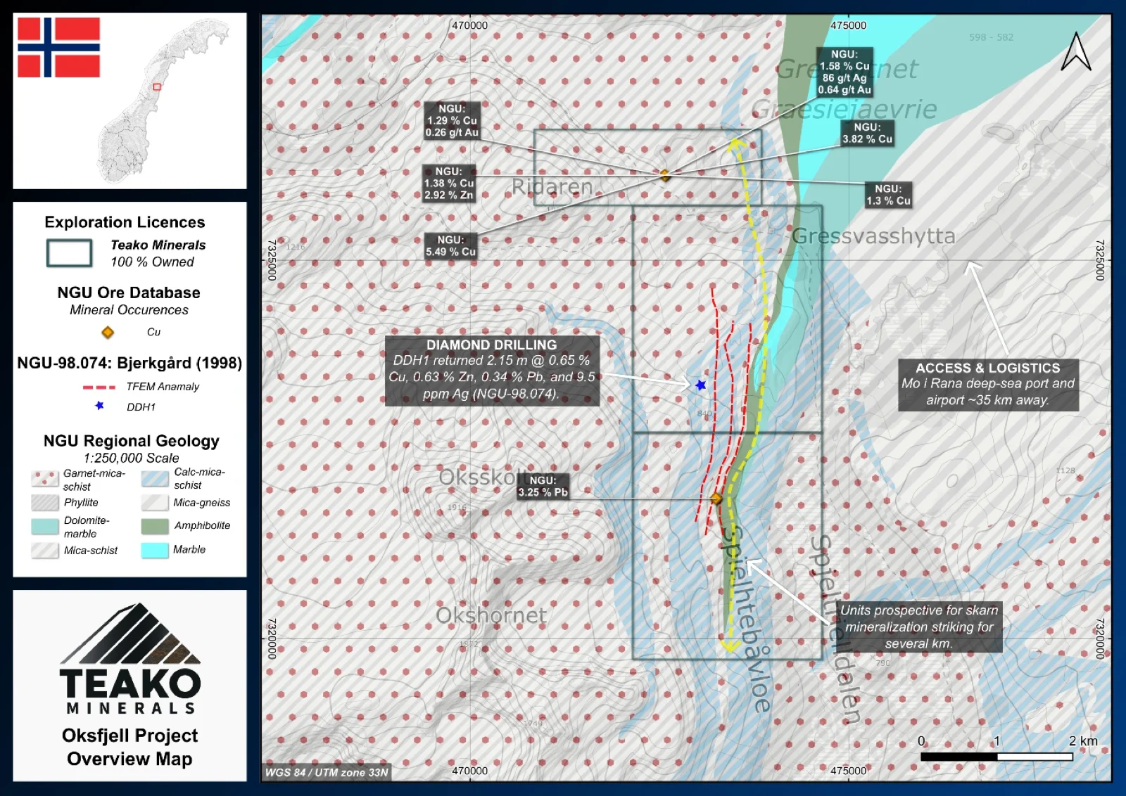
Teako’s 100% owned Oksfjell Project covers 18 km2 and is located in the Hemnes municipality, Nordland, within the Okstindan region. Previous work by the NGU identified encouraging sulphide mineralization that remains largely untested by modern exploration. Geologically, the licence area lies within a meta-sedimentary sequence comprising mica schists, marble-rich units (Anders Group), quartz-feldspathic schists (Malvatn unit), amphibolites and minor ultramafics. With Grasvatnet and Rabotsbekken two skarn occurrences are recognized. Rock samples at Grasvatnet returned 2.20 % Cu, 0.59 % Zn, 23 ppm Ag and 230 ppb Au1. Samples from a galena-rich zone at Rabotsbekken resulted in 3.2 % Pb (Bjerkgård and Larsen, 1996)1. Past exploration by the NGU comprised soil sampling, an EM survey and a single diamond drill hole returning 2.15 m @ 0.65 % Cu, 0.63 % Zn, 0.34 % Pb and 9.5 ppm Ag (Dalsegg, 1996)1. This mineralization is interpreted as a possible exhalite horizon, potentially linked to a concealed massive sulphide body at depth. The NGU concluded that the area holds potential to host more undiscovered mineralization and recommends further investigations (Bjerkgård and Larsen, 1996).
{{fig:1}}
1Teako has not performed sufficient work to verify the published data reported above, but the Company believes this information to be considered reliable and relevant. Results reported are maximum values and may not be representative of all samples collected within the area being evaluated
2References made to nearby mines and analogous deposits provide context for the regional targets but are not necessarily indicative that these targets host similar tonnages or grades of mineralization.
References
NGU report 96.157. Terje Bjerkgard & Rune B. Larsen. 1996. Follow-up studies in the Okstindan area, the Rödingsfjäll Nappe Complex, Nordland, Norway.
NGU report 96.114. Einar Dalsegg. 1996. TFEM-malinger Grasvatnet, Hemnes, Nordland.
NGU report 97.106. Reidar Krog. 1997. Soil geochemistry of the Bleikvassli area (Status Report No. 3). Detailed investigations of the Grasvatnet area.
NGU report 98.074. Terje Bjerkgard. 1998. The Bleikvassli Project, Field report 1997.
References to the ‘NGU’ regard the ‘Norwegian Geological Survey’, in particular, their Resource Database and are consolidated under this citation for simplicity. For all data sourced from this resource, please refer to: https://geo.ngu.no/kart/mineralressurser_mobil/?lang=eng
Exploration-stage project. Any historical production, grades or estimates quoted in project descriptions are historical in nature, have not been verified by the Company as current mineral resources or reserves, and should not be relied upon. See the cautionary statements and the Qualified Person statement.