


Hydrothermal-style Cu-Zn-Pb project of roughly 27.0 km² in Southern Norway.
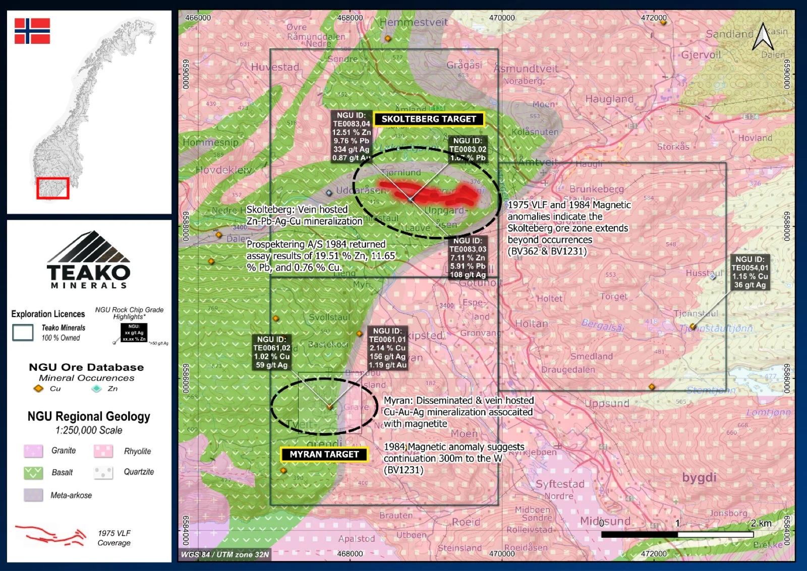
Teako’s 100% owned Skolteberg project covers 27 km2 and is part of the Eikland Base Metals District in Tokke Municipality, Telemark, known to host Cu, Zn, Pb, Mo, Mn, Ag, and Au. The geology is dominated by rocks of the Bandak Group (~1.16 Ga), comprising volcanic and sedimentary units such as metasediments, quartzites, and mafic to felsic lava flows and porphyries. The area was strongly affected by the Sveconorwegian Orogeny (ca. 1140–960 Ma), resulting in folding, faulting, and late-stage granitic intrusions (Laajoki, 2002). The Skolteberg target area includes the historic Skolteberg Mine2 and the North and South Skolteberg geophysical targets within the Raudbergnut Copper Field. Cu–Pb mineralization occurs in quartz veins and lenses within amphibolite and as disseminations along a zone extending more than 250 m. Historical sampling returned up to 19.51 % Zn, 11.65 % Pb, and 0.76 % Cu (NGU ore database)1. Geophysical surveys confirmed conductive zones over ~300 m and indicate possible extensions up to 100 m east and west of the known mineralization. At South Skolteberg (Graver Mine), mineralization is similar but richer in copper, with seven samples averaging 2.5 % Cu1,2. Magnetic data show a strong anomaly extending beyond the exposed mineralization.
The Skolteberg project is among the most promising targets in the Eikland district due to its documented base metal grades and potential for undiscovered mineralization at depth. Literature research and prospecting results suggest the presence of a potentially continuous mineralized zone extending for about 250 m with an estimated thickness of up to 10 m, although the full extent of the mineralization remains poorly constrained. At least four Cu–Zn–Pb occurrences have also been identified 0.5–2 km to the west, which may belong to the same mineralizing system and occur within the same stratigraphic horizon (Nilsen, 1984).
{{fig:1}}
1Teako has not performed sufficient work to verify the published data reported above, but the Company believes this information to be considered reliable and relevant. Results reported are maximum values and may not be representative of all samples collected within the area being evaluated
2References made to nearby mines and analogous deposits provide context for the regional targets but are not necessarily indicative that these targets host similar tonnages or grades of mineralization.
References
Laajoki, K., Corfu, F. & Andersen (2002), T.: Lithostratigraphy and U-Pb geochronology of the Telemark supracrustals in the Bandak-Sauland area, Tele mark, South Norway. Norsk Geologisk Tidsskrift, Vol. 82, pp. 119-138. Trondheim 2002, ISSN 029-196X.
BV1231: Nilsen (1984) Rekognoserende geofysiske undersøkelser(mgnetometri), kjemiske analyser og vurdering av mineraliseringer I omradet Bandak – Kviteseid. Prospektering A/S.
References to the ‘NGU’ regard the ‘Norwegian Geological Survey’, in particular, their Resource Database and are consolidated under this citation for simplicity. For all data sourced from this resource, please refer to: https://geo.ngu.no/kart/mineralressurser_mobil/?lang=eng
Exploration-stage project. Any historical production, grades or estimates quoted in project descriptions are historical in nature, have not been verified by the Company as current mineral resources or reserves, and should not be relied upon. See the cautionary statements and the Qualified Person statement.