


Hydrothermal-style Cu project of roughly 17.0 km² in Southern Norway.
Teako’s 100% owned Myklevatn project covers 17 km2 and is part of the Eikland Base Metals District in the Tokke Municipality, Telemark, known to host Cu, Zn, Pb, Mo, Mn, Ag, and Au. The area benefits from good accessibility and infrastructure, with Norwegian County Road 38 running northwest–southeast south of the licence blocks, European Route E134 to the north, and several smaller local roads throughout the district.
The geology is dominated by rocks of the Bandak Group (~1.16 Ga), composed of volcanic and sedimentary units including quartzites and mafic to felsic lava flows. The area was strongly affected by the Sveconorwegian Orogeny (ca. 1140–960 Ma), producing widespread folding, faulting, and late-stage granitic intrusions (Laajoki et al, 2002).
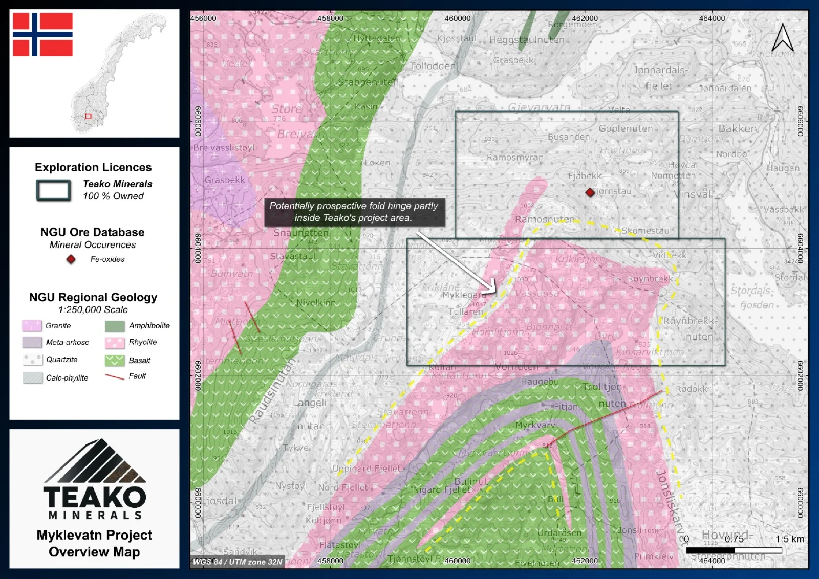
The Myklevatn greenfield target explores the northern continuation of the Morgedal Cu Field, which hosts chalcopyrite and bornite mineralization in quartz veins and lenses within felsic porphyry1. Mineralization may be controlled by shear-related fabrics acting as conduits for metal-bearing fluids. The Myklevatn licence covers a large portion of this felsic porphyry, including a major fold hinge where the unit thickens. Extensional zones along the fold crest provide favourable sites for veins, dykes, and pegmatites. Initial work should focus on sampling known occurrences to confirm grades and characterize mineralization, followed by detailed geological mapping of the fold hinge and limbs. High-density geochemical surveys and high-resolution geophysical methods (e.g., EM or IP) are recommended to define targets for future drilling.
{{fig:1}}
1Teako has not performed sufficient work to verify the published data reported above, but the Company believes this information to be considered reliable and relevant. Results reported are maximum values and may not be representative of all samples collected within the area being evaluated
References
Laajoki, K., Corfu, F. & Andersen (2002), T.: Lithostratigraphy and U-Pb geochronology of the Telemark supracrustals in the Bandak-Sauland area, Tele mark, South Norway. Norsk Geologisk Tidsskrift, Vol. 82, pp. 119-138. Trondheim 2002, ISSN 029-196X.
References to the ‘NGU’ regard the ‘Norwegian Geological Survey’, in particular, their Resource Database and are consolidated under this citation for simplicity. For all data sourced from this resource, please refer to: https://geo.ngu.no/kart/mineralressurser_mobil/?lang=eng
Exploration-stage project. Any historical production, grades or estimates quoted in project descriptions are historical in nature, have not been verified by the Company as current mineral resources or reserves, and should not be relied upon. See the cautionary statements and the Qualified Person statement.