Overview
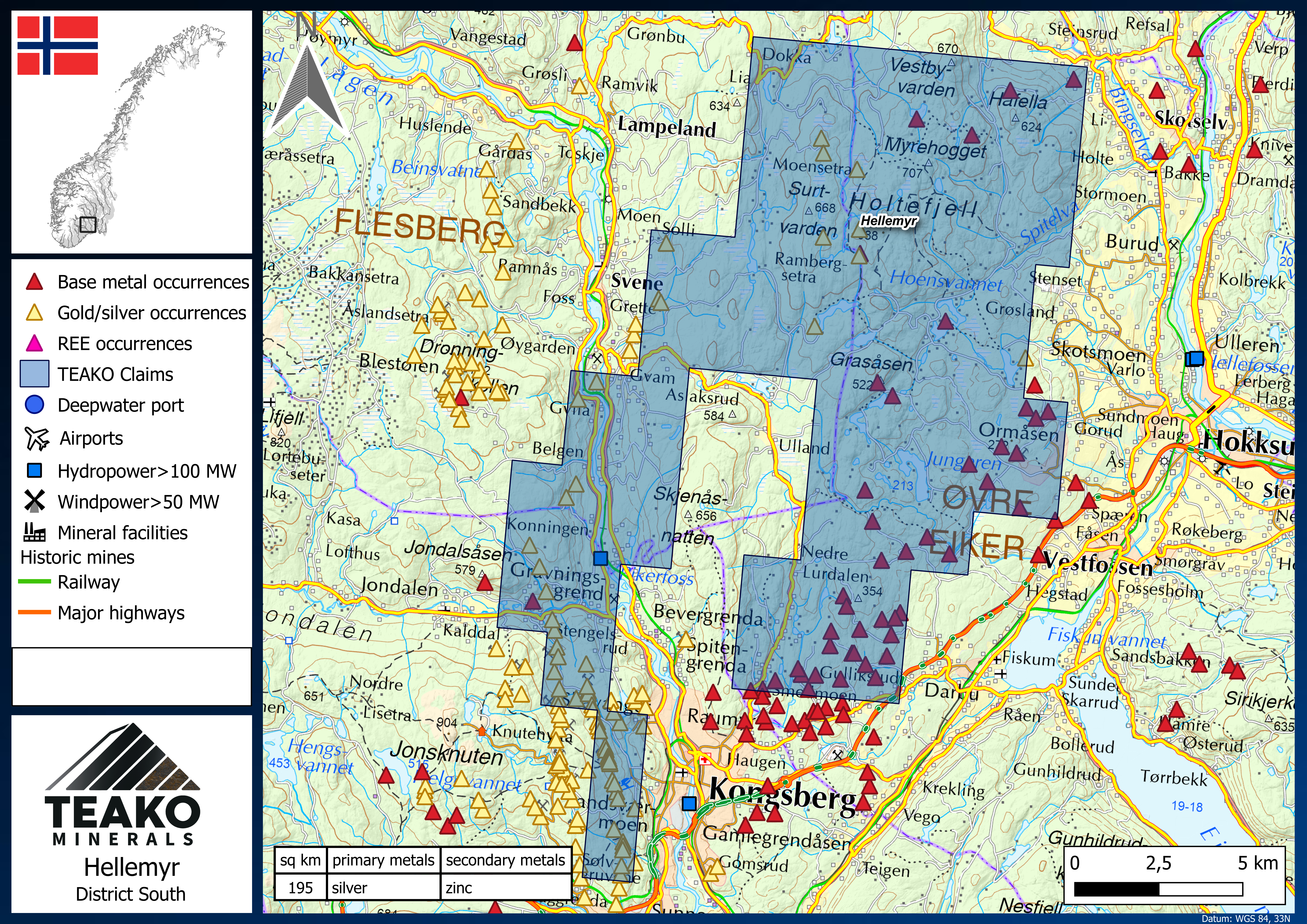
Hellemyr
Location
Southern Norway
Size
195 sq. km
Primary Metals
Silver
Secondary Metals
Zinc-Copper-Gold
Description
The Hellemyr project area has on June 25 been combined with the Company’s Holtefjell project by way of staking additional claims. It now consists of 22 contiguous license blocks that straddle the border of the Ovre Eiker, Flesberg, and Kongsberg in the county of Buskerud. The project measures 195 sq. km. in size and is located between the cities of Kongsberg and Hokksund. On June 25, it was announced that a field crew has been mobilized to include Hellemyr in the Companys summer exploration program.
The Hellemyr project is situated within the historical Kongsberg silver mining district and contains a range of base metal occurrences and a strong N-S-oriented gold and silver trend. The project area hosts the historic Bergsgruva base metal mine, which was in production four times between 1818 and 1889. In the last two periods (1874-1879 and 1885-1889), approximately 18,200t of ore at around 4% Cu were reported extracted.[i]
The project benefits from highly developed and well-functional infrastructure such as roads, railways, deep-sea ports, hydropower stations, and airports nearby. Access to the project is along several main roads including the E134. Minor roads and forest tracks throughout the license area are usually in good condition. Apart from historical mining activities, several exploration campaigns have been carried out throughout the 20th century. However, the area remains highly underexplored with regard to modern methods.
The Hellemyr project area is situated within the Kongsberg complex, a series of heavily deformed, Proterozoic gneisses, amphibolites, tonalites, and diorites. This suite of rocks was heavily influenced in the Sveconorwegian Orogeny approximately 1100-1200Ma. Permian-aged quartz and/or calcite veins commonly crosscut sulphide-enriched layers (fahlbands) in the Proterozoic basement forming the environment in which many of the area’s historical silver mines are found.
Mineralization on the Hellemyr property consists largely of polymetallic, low-sulphidation epithermal deposits forming within veins and zones of brecciation. Generally, these deposits are steep structures, oriented NE-SW, roughly parallel to regional foliation. Ore minerals such as pyrite, chalcopyrite, sphalerite, and galena are usually associated with quartz veins.
Hellemyr and the surrounding area has a long history of mining and exploration activities. Since the early 1600s up until the 1950s, the occurrences have been exploited for silver and base metals. A number of these historic workings are situated within Teako’s project area and provide valuable insights about the area’s mineralization. The eastern side of the Hellemyr claim hosts the edge of the Eiker base metal field, which comprises several deposits including the aforementioned Bergsgruva, Asgruva, Haugset and Humlebekk. The Humlebekk deposit is found on the eastern extent of the project area and boasts silver, copper and zinc mineralization with hand samples returning grades of up to 2% silver. It was exploited briefly from 1860-1870.
More recent work has been undertaken in 1946 by Geofysisk Malmleting comprising an EM and a VLF (very low frequency) survey. In 1965 Stordø Kisgruber AS investigated the area for tungsten deposits. Activities by the NGU during the 1970s include extensive geochemical prospecting for REEs and detailed mapping and cataloguing of the area’s historic silver workings. Most recently from 2008 to 2011, the NGU conducted airborne geophysics in the region which has been used extensively by Teako Mineral’s staff to generate exploration targets in the area.
[i] Bjerkgård, T. et al. (2020) Mineralressurser i området Kongsberg-Modum-Ringerike, Buskerud (https://openarchive.ngu.no/ngu-xmlui/handle/11250/2663719)
