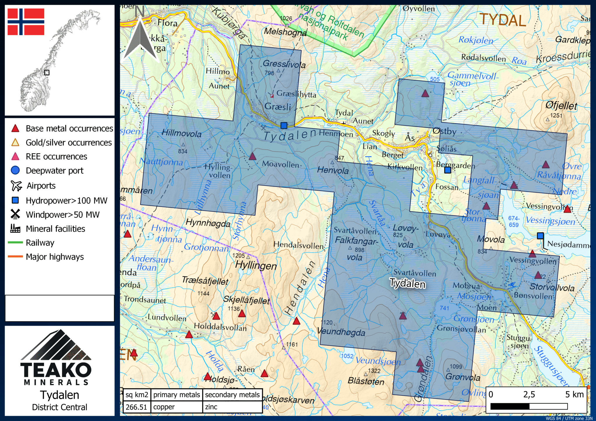
Figure 1: The Tydalen Project Licsenses
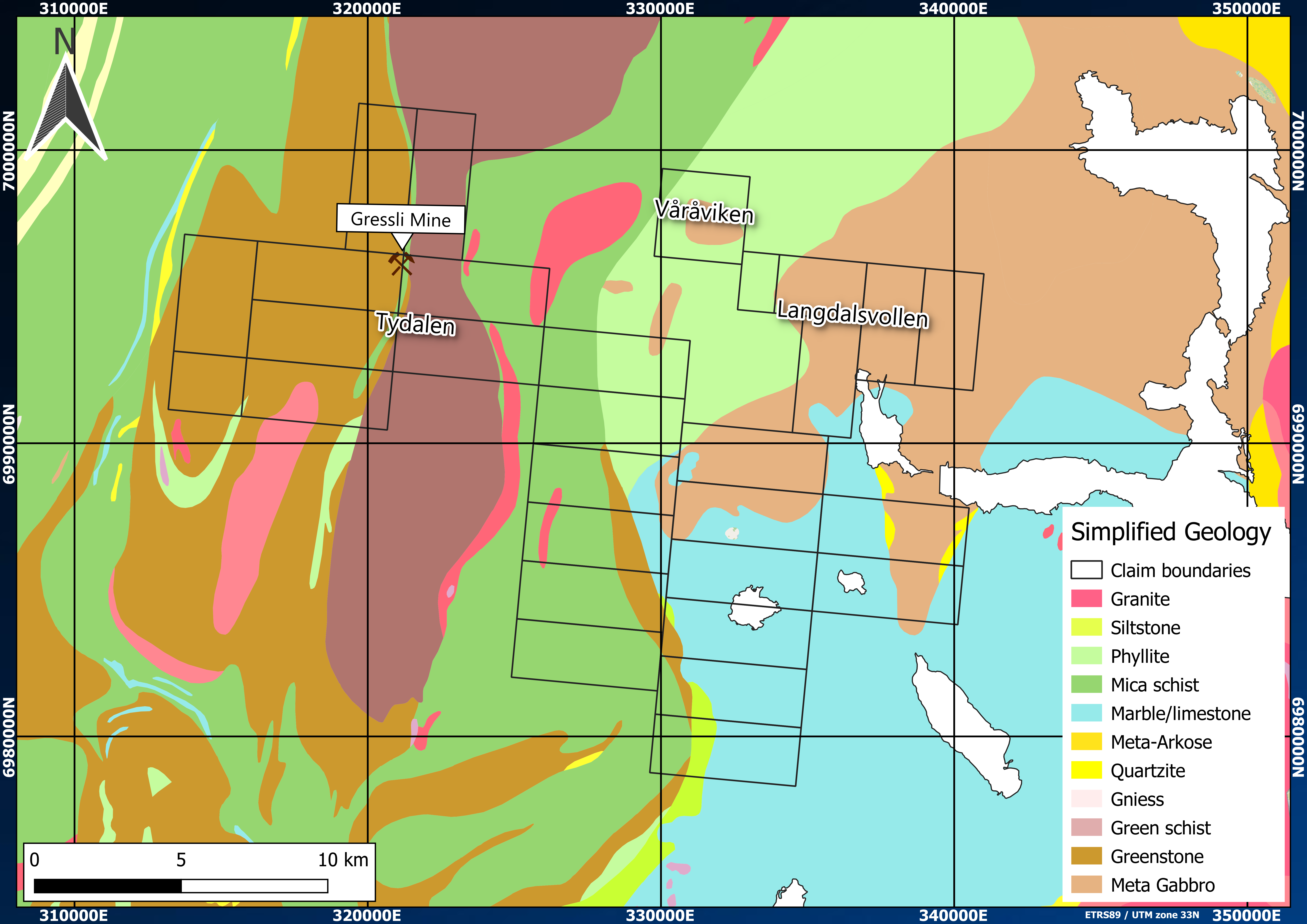
The claim is located in the Meråker nappe, part of the Upper Allochthon of the Central Norwegian Caledonides. Several sulphide deposits, including the former Gressli Cu-Zn mine (Figure 2), are hosted within the Meråker nappe. This greenstone belt is comprised of submarine vulcanites, metapelites and graphite schists, and these are overlain by conglomerate units of the Sulåmo Group.
The main mineralized unit is known as the Gressli belt and consists dominantly of intermediate to basic extrusives of the Fundsjø Group, graphite schists, and mafic intrusions. The Hersjo-Fundsjø greenstone belt hosts several stratabound sulphide deposits, including the former Gressli mine. More than 20 VMS-style deposits are reported to have been mined historically, with five deposits reported to contain >1Mt of Cu-Zn-bearing ore [2].
The Tydal-Gressli area specifically comprises two gabbro units in the North and the East, whereas the West of the claim is characterized by a diabase-porphyritic rock. The center shows trondhjemites, amphibolites (mica schists), quartzites, and graphitic schists (Figure 5). Generally, the strike direction is N-S, although the strike changes around the Gressli mine to E-W with a dip towards the south. Possibly, this is due to a large thrust zone extending over the area.
The sulphide mineralization in the area generally occurs as stratabound pyrite with pyrrhotite, chalcopyrite, and sphalerite. Several levels in the Gressli belt host dm to m thick schistose to cherty carbonaceous horizons, often containing banded pyrrhotite-pyrite-chalcopyrite-arsenopyrite impregnations.
Historic production was based on Cu values from 1-3% and Zn values from 3-15% [3], and elevated levels of As, Ni, Co, Mo, V, Cr, Fe, S, U, Ti, and Zr are documented in rock samples. The Gressli mineralization is believed to occur as clusters of massive sulphide lenses dipping to the southwest with unknown extension at depth.
Extensions of the mineralization along strike beyond the historically mined occurrences are likely. The Gressli belt can be traced continuously for 5km towards the south and discontinuously for 12km towards the north [3]. The Rødhammeren deposit is located a few kilometers south of the Tydalen project. It is hosted in a stratigraphically equivalent unit to the Gressli belt, suggesting a larger extension of the possibly mineralized area. Furthermore, the same sphalerite-pyrite-(chalcopyrite-galena) mineralization occurs in felsic pyroclastites west of the gabbro complex.
The Langdalsvollen and Våråviken areas are located east of Tydalen-Gressli (Figure 5). These areas’ geology differs from the Gressli area with sulphide mineralization concentrating within biotite gneisses bordering an intrusive granitic body to the west. The metamorphic grade ranges from the lower amphibolite facies in the east to the higher-grade amphibolite facies in the west. In Våråviken, the mineralization comprises pyrrhotite, pyrite, sphalerite, chalcopyrite, galena, marcasite (supergene), and secondary pyrite.
It can be summarized that the host rocks of the Gressli, the Langdalsvollen, and the Våråviken areas are different. Interpretation of depositional settings leads to the Gressli mineralization forming in a vent proximal environment compared to a likely more distal setting for the Langdalsvollen and Våråviken areas [4].
2: (1996a) The Gressli deposit, Tydal, central Norwegian Caledonides. rep. Trondheim: NGU.
3: Gvein, O. (1976) Boring I gressli. Available at: https://dirmin.no/sites/default/bibliotek/BV1800.pdf (Accessed: 25 June 2024).
4: Ferriday, I. (1983) Geological Survey, Tydal. rep. BP Minerals. BV 7367
