


Pegmatite-style U-Th-REE project of roughly 46.0 km² in Northern Norway.
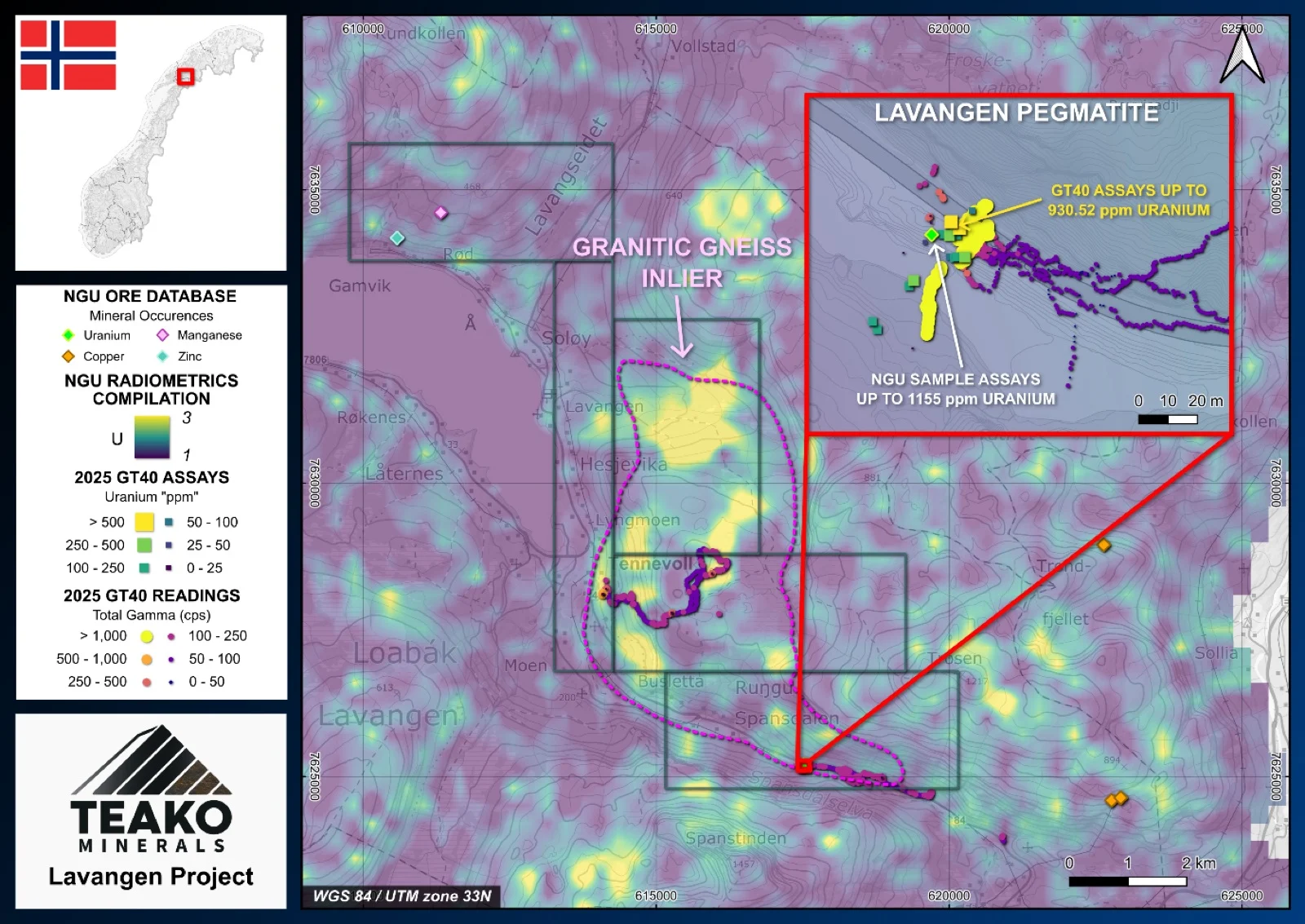
The 100% owned Lavangen Project covers 46 km2 and is situated 37 km north of the major port of Narvik. The Lavangen project contains the pegmatite hosted Spansdalen uranium occurrence, which was discovered during one of the NGU’s radiometric surveys in 1983 (Hatling 1983). The mineralized area consists of a 10cm zone within the larger Spandalen pegmatite1.
The Lavangen project area is situated in the uppermost allochthon of the Koli Knappe Complex and underlain by a series of metamorphic rocks consisting of granitic gneiss, phyllites, mica schists, garnet schists and carbonates.
Samples were taken from the Spandalen occurrence by the NGU in 1995. Two samples were taken from the fracture zone with U grades 690ppm and 1155ppm1. The Teako field team visited the Lavangen pegmatite over the period of 4 days during summer 2025. The pegmatite and the area surrounding was mapped using a GT40 device to record gamma values. The team identified a high number of pegmatites during the attempted traverse to the eastern side. As this was a reconnaissance programme the team clearly identified areas for follow up exploration.
The Spandalen occurrence itself features similarities with other occurrences further away from the project area. This, therefore, could mean that extensions to the Spandalen occurrence and other mineralized areas are present and further exploration of the geological trends and similarities are required.
{{fig:1}}
1Teako has not performed sufficient work to verify the published data reported above, but the Company believes this information to be considered reliable and relevant. Results reported are maximum values and may not be representative of all samples collected within the area being evaluated
References
Harald Hatling (1983) Radiometriske bilmalinger i Trams 1983, NGU Uranprosjektet, NGU-rapport 84.062, 84_062.pdf
References to the ‘NGU’ regard the ‘Norwegian Geological Survey’, in particular, their Resource Database and are consolidated under this citation for simplicity. For all data sourced from this resource, please refer to: https://geo.ngu.no/kart/mineralressurser_mobil/?lang=eng
Exploration-stage project. Any historical production, grades or estimates quoted in project descriptions are historical in nature, have not been verified by the Company as current mineral resources or reserves, and should not be relied upon. See the cautionary statements and the Qualified Person statement.